Introduction
The primary intersection in the town of Brighton is where Main Street, Prince Edward and Young Streets meet in the middle of town. The intersection of Dundas and Young Streets is close by to the north and Number 2 Highway makes a jog south on Prince Edward, to continue east on Elizabeth Street. The physical nature of this intersections may seem a bit odd to the modern traveler and local historians sometimes are asked to explain.
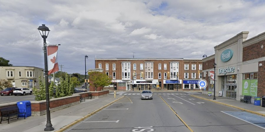
Early in 2025, Bruce Davis, a member of the Brian Todd Community Fund sent a request to the Brighton Heritage Advisory Committee, including a letter he had written on the same topic in 2023. He suggested that there should be some kind of historical display at the intersection of Main, Young and Prince Edward Streets. Bruce’s experience of walking on the sidewalk in front of the Sobey’s Parking lot made him wonder about the history of this important intersection in Brighton. This would be a perfect place for a historical display.
Dan Buchanan, the History Guy of Brighton, is a member of the Brighton Heritage Advisory Committee and his response to this request was to say that he planned to continue the project called “Around Town” with the objective of documenting every property in Brighton. Main Street and Prince Edward Streets have been done and Young Street has been started, although other projects have intervened.
The History Guy committed to doing the underlying research regarding the lands immediately adjacent to the intersection of Main, Young and Prince Edward Streets. To this end, he would provide the information that might result in a historical display for this location. A report would be provided for the next BHAC meeting in May 2025.
The following report is the underlying detailed documentation that has resulted from the research on the properties around the main intersection in Brighton. From this detail it should be relatively easy to generate verbiage for historical displays of any type.
Dan Buchanan, the History Guy of Brighton, is a member of the Brighton Heritage Advisory Committee and his response to this request was to say that he planned to continue the project called “Around Town” with the objective of documenting every property in Brighton. Main Street and Prince Edward Streets have been done and Young Street has been started, although other projects have intervened.
The History Guy committed to doing the underlying research regarding the lands immediately adjacent to the intersection of Main, Young and Prince Edward Streets. To this end, he would provide the information that might result in a historical display for this location. A report would be provided for the next BHAC meeting in May 2025.
The following report is the underlying detailed documentation that has resulted from the research on the properties around the main intersection in Brighton. From this detail it should be relatively easy to generate verbiage for historical displays of any type.
In the Beginning
After the War of Independence ended in 1783, many loyalists came to the British colonies to the north. The Constitutional Act of 1791 divided the old province of Quebec into Upper and Lower Canada. This was done to provide a province for the French in Quebec to live under their own culture and laws and to provide a different province, to the west, for English settlers to make their new homes under their own culture and laws.
Surveys had been conducted in the previous years along the St. Lawrence and around the Bay of Quinte to identify townships that were divided into concessions and lots where settlers could establish farms. Early in the 1790s, Augustus Jones, a surveyor, was sent to survey the lots along the north shore of Lake Ontario between York and the Trent River. This survey included only the first few lots from the lakeshore in order to get the job done quickly and meet the growing demand for land. Over the next few decades, subsequent surveys would include all the concessions to the north in the townships.
Murray and Cramahe Townships were initially surveyed at this time. The southern part of the boundary between Cramahe and Murray townships can be identified today as Young, Prince Edward and Cedar Streets to Presqu’ile Bay. The line extended north a little to the east of Number 30 Highway where small parts of the original township line can be identified today as Florence Road, west of Hilton and McCann Road north of Codrington.
This segment of a sketch of old Cramahe Township reflects the original Patent holders for the lots at the far south-east corner of Cramahe Township. James Richardson, the commercial ship captain and merchant in Kingston obtained both lot 1 in the Broken Front and lot 1 in concession 1. The next lot north, lot 1 of the second concession, shows Edward Goodyear as the original patent holder.
Surveys had been conducted in the previous years along the St. Lawrence and around the Bay of Quinte to identify townships that were divided into concessions and lots where settlers could establish farms. Early in the 1790s, Augustus Jones, a surveyor, was sent to survey the lots along the north shore of Lake Ontario between York and the Trent River. This survey included only the first few lots from the lakeshore in order to get the job done quickly and meet the growing demand for land. Over the next few decades, subsequent surveys would include all the concessions to the north in the townships.
Murray and Cramahe Townships were initially surveyed at this time. The southern part of the boundary between Cramahe and Murray townships can be identified today as Young, Prince Edward and Cedar Streets to Presqu’ile Bay. The line extended north a little to the east of Number 30 Highway where small parts of the original township line can be identified today as Florence Road, west of Hilton and McCann Road north of Codrington.
This segment of a sketch of old Cramahe Township reflects the original Patent holders for the lots at the far south-east corner of Cramahe Township. James Richardson, the commercial ship captain and merchant in Kingston obtained both lot 1 in the Broken Front and lot 1 in concession 1. The next lot north, lot 1 of the second concession, shows Edward Goodyear as the original patent holder.
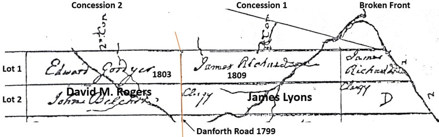
Added to this sketch is an indication of the Danforth Road which was built between York and Kingston in 1799 and 1800. At this location, it ran along the line between concessions 1 and 2, which would one day become Main Street, Brighton. Edward Goodyear was born in Connecticut, served with the patriots during the war, then was married and had a family. However, in August 1792, we see that he was a batteau-man on the St. Lawrence River. He was one of the crew that escorted the Prince Edward from Montreal to Newark, the capital of the new province of Upper Canada.
Edward Goodyear remained in Upper Canada after his batteaux days were over and obtained the Patent from the Crown for his service. His land grant was all 200 acres of lot 1, concession 2, Cramahe Township, Northumberland County. In fact, Edward Goodyear was the first owner of the land immediately north of Main Street and west of Young Street. He had a second family in his new home and would remain until his death around 1837.
A major event happened at the south end of lot 1 in 1799 and 1800 when Asa Danforth built his road from York to Kingston, passing along the line between concessions 1 and 2 in this area. Edward Goodyear now had a main road along the south border of his property.
The Patent from the Crown for Concession 1, Lot 1 was granted in 1809 to James Richardson Sr., the trader and commercial ship captain who had operated out of Kingston since the early 1790s. He was engaged in shipping supplies and trade goods from Kingston to York and many places around Lake Ontario. The government was ramping up survey work in order to have many townships prepared for settlers and that activity created demand for shipping as well. Captain Richardson was one of the most experienced and respected sailors on the lake.
James Richardson became convinced that Presqu’ile Bay was an important place and he was intent on establishing a store on the north shore of the bay. He and others were sure that the road down to the bay would be where an important town would develop, although competition developed after the Danforth Road was built as people wanted to set up shop on the main east-west road more than on the road to the bay.
Edward Goodyear remained in Upper Canada after his batteaux days were over and obtained the Patent from the Crown for his service. His land grant was all 200 acres of lot 1, concession 2, Cramahe Township, Northumberland County. In fact, Edward Goodyear was the first owner of the land immediately north of Main Street and west of Young Street. He had a second family in his new home and would remain until his death around 1837.
A major event happened at the south end of lot 1 in 1799 and 1800 when Asa Danforth built his road from York to Kingston, passing along the line between concessions 1 and 2 in this area. Edward Goodyear now had a main road along the south border of his property.
The Patent from the Crown for Concession 1, Lot 1 was granted in 1809 to James Richardson Sr., the trader and commercial ship captain who had operated out of Kingston since the early 1790s. He was engaged in shipping supplies and trade goods from Kingston to York and many places around Lake Ontario. The government was ramping up survey work in order to have many townships prepared for settlers and that activity created demand for shipping as well. Captain Richardson was one of the most experienced and respected sailors on the lake.
James Richardson became convinced that Presqu’ile Bay was an important place and he was intent on establishing a store on the north shore of the bay. He and others were sure that the road down to the bay would be where an important town would develop, although competition developed after the Danforth Road was built as people wanted to set up shop on the main east-west road more than on the road to the bay.
In a personal show of support for his idea, Captain Richardson built a substantial two-story frame house on the north shore of Presqu’ile bay in the southern part of his land grant, lot 1 in the Broken Front of Cramahe Township. This house would be a symbol of Brighton history for more than a century and a half before it was demolished in 1958.
Little would happen in this area until after the upheavals of the War of 1812 ended. Then, in 1816, Edward Goodyear sold four acres at the south-east corner of lot 1, concession 2 to Thomas Dorman Sanford, a member of a very early settler family that would have a major impact on this community over the years. In the years after the War of 1812, major changes happened.
Very soon Mr. Sanford built a large building a little west of the Murray/Cramahe border and far enough north of the Danforth Road to allow for easy turning for teams of horses that were drawing teamster wagons or stage coaches. This building would house a hotel and tavern that would become a popular stage stop on the Danforth Road.
Initially, when the Sanford Hotel began business here, the original Danforth Road came from the west along the concession line and then angled to the north-east to follow what we call Dundas Street. Danforth had been working fast to meet his contract and his instructions were to keep the road on higher ground. In this case, the road went directly east into the settlement that would be called Smithfield after John Drummond Smith, an early settler. This same tactic can be seen at other places, such as north of Cobourg.
In this situation, Thomas Dorman Sanford had built his hotel well north of the road, backing on the lane that would become an important street in Brighton, taking his name. This left plenty of space available in front of the hotel for stage coach drivers, who were always in a big hurry, to turn around and head off in one direction or the other. The importance of this primary east-west road across the north shore of Lake Ontario would grow over the years and the traffic at the Sanford Hotel would increase at the same time.
Little would happen in this area until after the upheavals of the War of 1812 ended. Then, in 1816, Edward Goodyear sold four acres at the south-east corner of lot 1, concession 2 to Thomas Dorman Sanford, a member of a very early settler family that would have a major impact on this community over the years. In the years after the War of 1812, major changes happened.
Very soon Mr. Sanford built a large building a little west of the Murray/Cramahe border and far enough north of the Danforth Road to allow for easy turning for teams of horses that were drawing teamster wagons or stage coaches. This building would house a hotel and tavern that would become a popular stage stop on the Danforth Road.
Initially, when the Sanford Hotel began business here, the original Danforth Road came from the west along the concession line and then angled to the north-east to follow what we call Dundas Street. Danforth had been working fast to meet his contract and his instructions were to keep the road on higher ground. In this case, the road went directly east into the settlement that would be called Smithfield after John Drummond Smith, an early settler. This same tactic can be seen at other places, such as north of Cobourg.
In this situation, Thomas Dorman Sanford had built his hotel well north of the road, backing on the lane that would become an important street in Brighton, taking his name. This left plenty of space available in front of the hotel for stage coach drivers, who were always in a big hurry, to turn around and head off in one direction or the other. The importance of this primary east-west road across the north shore of Lake Ontario would grow over the years and the traffic at the Sanford Hotel would increase at the same time.
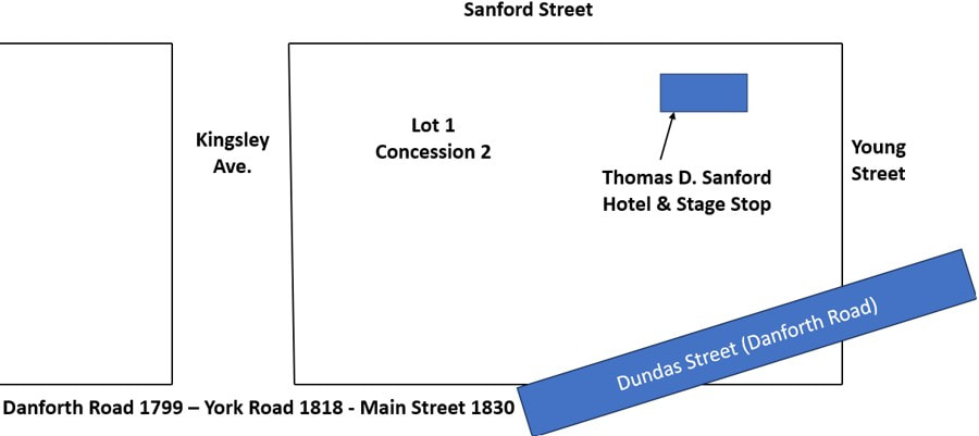
It is not clear from documentation exactly when this situation changed, but it may have been rather soon after the War of 1812 was over. The government saw that the Danforth Road was in poor shape and that the route of the original road did not serve the current needs of travelers. Part of the upgrade of the road was to change the route of the road in some places to better reflect the settlement of towns and the actual traffic of people since the first road was completed in 1800. One of those places was here at the border of Murray and Cramahe Townships. The new road, in its early days called the York Road, would not swing north in front of the Sanford Hotel, but went straight to Prince Edward Street. It jogged south and then east on Elizabeth Street to follow a more direct line all the way to Trent Port where a ferry took travelers over the Trent River. A bridge would be built over the river in 1834.
Speculation might suggest that this change may not have happened right away or as a matter of deliberate road construction. People simply began to keep to the right when they came east on Main Street, and turned right to continue on the York Road. Eventually, the beaten track would define this place as we see it today, as a squared-off, three-way intersection. The change meant that Dundas Street east to Smithfield was no longer part of the main east-west road. It remained as an important local road, but this new and unusual three-way intersection dramatically reduced the traffic on Dundas Street. Travelers from outside the area were simply driving through and would not think twice about following the new route.
Speculation might suggest that this change may not have happened right away or as a matter of deliberate road construction. People simply began to keep to the right when they came east on Main Street, and turned right to continue on the York Road. Eventually, the beaten track would define this place as we see it today, as a squared-off, three-way intersection. The change meant that Dundas Street east to Smithfield was no longer part of the main east-west road. It remained as an important local road, but this new and unusual three-way intersection dramatically reduced the traffic on Dundas Street. Travelers from outside the area were simply driving through and would not think twice about following the new route.
The Corner of Main and Young Streets
Now we can deal with the three primary areas that surround the intersection at Main, Young and Prince Edward Streets. Let’s continue with the north side of Main Street, west of Young. For many years, the corner where Sobey’s is today was occupied by the Sanford Hotel and a large turning space near the road. There is little evidence of buildings near the road at this corner until the 1840s.
The most critical event in early Brighton history occurred on April 2 1831 when the movers-and-shakers from the community gathered at Simeon Kellogg’s hotel/tavern on the south side of Main Street at Prince Edward Street. They held a meeting in the Union Hall in the hotel and decided that there should be one village in this place rather than the two straggling clusters of buildings at Singleton’s Corners at the east end and Bettes Corners at the west end. Competition between these two places was not healthy and it led to a lot of inconvenience, so it needed to end.
Joseph Lockwood was appointed as the first Post Master of the new village and, as was customary, the post master had the responsibility of naming the post office, which would be the name of the village. He had grown up in Connecticut, but his family came originally from Brighton, England. He suggested the name and it was approved by the gathering. We might expect there was some aspirational thinking involved in taking on the name of a famous and popular summer resort on the sea in the old country. In any case, now there was just one village and one post office and the two earlier clusters would gradually grow together to form the village of Brighton.
After the village was created, the land along the main roads and streets in the village was sub-divided into smaller village lots. This step met the growing demand for small lots that could be used by merchants to establish a store or a home. Demand was highest on the main roads, especially for stores, in order to take advantage of growing traffic that would translate into growing sales. Prosperous merchants, professionals and tradesmen in the area yearned for an impressive and comfortable home for themselves and their families.
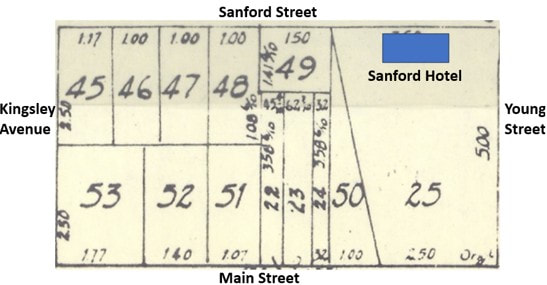
At the main intersection, the north-west corner was divided as we can see on this segment of Brighton Plan of 1866. Most of the land from Main Street up to the next laneway, called Sanford Street, was labelled as Lot 25. There was also a Lot 50 which was a long, angular space on the south-west side of Lot 25. Don’t even ask how that came to be!
The most critical event in early Brighton history occurred on April 2 1831 when the movers-and-shakers from the community gathered at Simeon Kellogg’s hotel/tavern on the south side of Main Street at Prince Edward Street. They held a meeting in the Union Hall in the hotel and decided that there should be one village in this place rather than the two straggling clusters of buildings at Singleton’s Corners at the east end and Bettes Corners at the west end. Competition between these two places was not healthy and it led to a lot of inconvenience, so it needed to end.
Joseph Lockwood was appointed as the first Post Master of the new village and, as was customary, the post master had the responsibility of naming the post office, which would be the name of the village. He had grown up in Connecticut, but his family came originally from Brighton, England. He suggested the name and it was approved by the gathering. We might expect there was some aspirational thinking involved in taking on the name of a famous and popular summer resort on the sea in the old country. In any case, now there was just one village and one post office and the two earlier clusters would gradually grow together to form the village of Brighton.
After the village was created, the land along the main roads and streets in the village was sub-divided into smaller village lots. This step met the growing demand for small lots that could be used by merchants to establish a store or a home. Demand was highest on the main roads, especially for stores, in order to take advantage of growing traffic that would translate into growing sales. Prosperous merchants, professionals and tradesmen in the area yearned for an impressive and comfortable home for themselves and their families.
At the main intersection, the north-west corner was divided as we can see on this segment of Brighton Plan of 1866. Most of the land from Main Street up to the next laneway, called Sanford Street, was labelled as Lot 25. There was also a Lot 50 which was a long, angular space on the south-west side of Lot 25. Don’t even ask how that came to be!
By 1831, when the village of Brighton was created, Thomas Dorman Sanford owned this land at the corner of the main road. In 1835, Thomas D. Sanford passed the land at the corner along with the hotel to his son, William Hawley Sanford who was only nineteen at the time. Very soon he would be married to Adeline Eliza Proctor, a daughter of Isaac C. Proctor and sister or John Edward Proctor.
William Hawley Sanford was now proprietor of the establishment that was the routine stopping place for the Royal Mail Line, the primary stage line between Toronto and Kingston with connections on to Montreal. Sometimes, the driver of the stage that swung into the yard in front of the hotel was William Weller, the owner and operator of the Royal Mail Line. He lived in Cobourg and was often busy looking after his steamboat on Rice Lake or his stage line to Hamilton, in which case he assigned his best drivers to take his place.
When he did take the time to drive himself, Mr. Weller was a popular fellow at these stage stops because he was always friendly and could spin tails with dramatic flair. On a more practical level, passengers on the stage coaches experienced the improvements Mr. Weller had implemented to make his stage lines run on time and provide good service to customers. It was not lost on the community that the mail arrived in good time as well.
When he did take the time to drive himself, Mr. Weller was a popular fellow at these stage stops because he was always friendly and could spin tails with dramatic flair. On a more practical level, passengers on the stage coaches experienced the improvements Mr. Weller had implemented to make his stage lines run on time and provide good service to customers. It was not lost on the community that the mail arrived in good time as well.
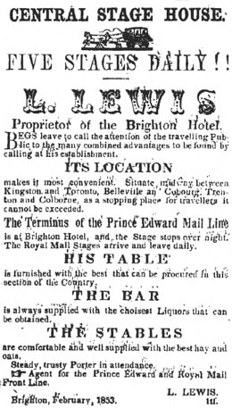
The hotel was very popular in the 1840s and into the 1850s. It was sometimes called the Brighton Hotel but more often the Sanford Hotel. In early 1853, management of the hotel was turned over to Mr. Lucius Lewis of Cannifton. He advertised aggressively using the local and regional newspapers. Here, the headline says “Central Stage House” and he is “Proprietor of the Brighton Hotel”.
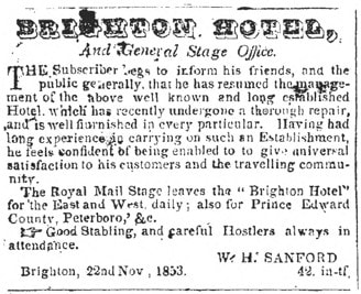
This arrangement only lasted a few months, probably due to the fact that Mr. Lewis became ill and passed away in June 1856. William H. Sanford took over as proprietor later that same year, placing this ad in the newspaper saying “The subscriber begs to inform his friends, and the public generally, that he has resumed the management of the above well-known wand long established Hotel, which has recently undergone a thorough repair, and is well furnished in every particular. Having had long experience in carrying on such an establishment, he feels confident of being enabled to give universal satisfaction to his customers and the travelling community. The Royal Mail Stage leaves the “Brighton Hotel” for the east and west daily; also for Prince Edward County, Peterboro, &c. Good stabling, and careful Hostlers always in attendance. W. H. Sanford, Brighton, 22nd Nov. 1853.”
This arrangement only lasted a few months, probably due to the fact that Mr. Lewis became ill and passed away in June 1856. William H. Sanford took over as proprietor later that same year, placing this ad in the newspaper saying “The subscriber begs to inform his friends, and the public generally, that he has resumed the management of the above well-known wand long established Hotel, which has recently undergone a thorough repair, and is well furnished in every particular. Having had long experience in carrying on such an establishment, he feels confident of being enabled to give universal satisfaction to his customers and the travelling community. The Royal Mail Stage leaves the “Brighton Hotel” for the east and west daily; also for Prince Edward County, Peterboro, &c. Good stabling, and careful Hostlers always in attendance. W. H. Sanford, Brighton, 22nd Nov. 1853.”
Other business was being done at this corner later in the 1840s. Robert C. Weller (1803-1879) was a son of Asa Weller and Anne Marsh, born at the Carrying Place. He was married in 1832 to Mary Dorman Sanford, a daughter of Thomas Dorman Sanford and Anna Hawley. The land records show that in 1838, William Hawley Sanford sold ½ acre in the south-east corner of Lot 25 to Robert Weller. This would be near the corner and would be used for a store.
Soon afterward, Thomas H. Sanford sold another small piece of land in the south-east corner of lot 25 to Isaac C. Proctor. This was the first location for a store run by his son, John Edward Proctor. In 1848, Isaac sold this property to the firm of Proctor and Squier, meaning the partnership between John Edward Proctor and Abijah Squier. This pair would also have a store across at 1 Young Street as well as near Ontario Street on the south side of Main Street.
A big change occurred along Young Street when Brighton Township was created on January 1, 1852. Legislation had been passed in Toronto in August 1851 which made many changes to counties and township across Canada west, but this one was unique. They took the western lots of Murray Township and the eastern lots of Cramahe Township, along with Presqu’ile Point and made a new township. No documents tell us exactly why this was done but we might speculate that several factors combined to motivate the change.
Murray and Cramahe Townships were now full of people and the populations of the two townships were greater than the normally recommended size in order to deliver services effectively. Also, Brighton Village had evolved over time to become a major local service center, but the border of Cramahe and Murray ran down the middle of town, creating a lot of confusion regarding access to municipal services.
There may be another reason. It was thought ideal to have a rural area of farmers serviced by a centrally located town where commercial, governmental, police and social services could be made available. The change that took effect on January 1, 1852 created a very effective structure with Brighton Township serviced by Brighton Village. The new road north through the township solidified this structure and made it work efficiently. If this was the objective of the change, it succeeded magnificently.
Soon afterward, Thomas H. Sanford sold another small piece of land in the south-east corner of lot 25 to Isaac C. Proctor. This was the first location for a store run by his son, John Edward Proctor. In 1848, Isaac sold this property to the firm of Proctor and Squier, meaning the partnership between John Edward Proctor and Abijah Squier. This pair would also have a store across at 1 Young Street as well as near Ontario Street on the south side of Main Street.
A big change occurred along Young Street when Brighton Township was created on January 1, 1852. Legislation had been passed in Toronto in August 1851 which made many changes to counties and township across Canada west, but this one was unique. They took the western lots of Murray Township and the eastern lots of Cramahe Township, along with Presqu’ile Point and made a new township. No documents tell us exactly why this was done but we might speculate that several factors combined to motivate the change.
Murray and Cramahe Townships were now full of people and the populations of the two townships were greater than the normally recommended size in order to deliver services effectively. Also, Brighton Village had evolved over time to become a major local service center, but the border of Cramahe and Murray ran down the middle of town, creating a lot of confusion regarding access to municipal services.
There may be another reason. It was thought ideal to have a rural area of farmers serviced by a centrally located town where commercial, governmental, police and social services could be made available. The change that took effect on January 1, 1852 created a very effective structure with Brighton Township serviced by Brighton Village. The new road north through the township solidified this structure and made it work efficiently. If this was the objective of the change, it succeeded magnificently.
The whole community of Brighton was shocked in the fall of 1858 when Dr. William Henry King poisoned his wife just up Sanford Street at the corner of Kingsley. William Henry King had just recently returned to Brighton, having grown up on a farm at Codrington, ten miles to the north. He and his wife, Sarah Lawson, had been separate a few years before, but family pressures motivated them to reconcile. Dr. King, now with a medical degree, returned to Brighton in the spring of 1858 so he could begin his medical practice. A large frame house had been built up from the corner of Sanford and Kingsley which the young couple rented and he began his medical practice. This house was called the Murdoff house in the 1960s and was demolished in the 1980s to make room for the parking lot for the Anglican church.
After a dalliance with a young friend of his wife’s and his brutal poisoning of Sarah, Dr. King fled, was caught and would be the defendant in a murder trial that was held in Cobourg in April 1859. He would be found guilty and hanged in Cobourg on July 9th, 1859. One might imagine the curiosity and gossip that would have engulfed the Sanford Hotel, located just a few dozen yards from the scene of the crime.
The Sanford Hotel was still under the management of William Hawley Sanford at the time of the Dr. King debacle, although he was showing more interest in his farm south-east of Brighton. The Sanford Hotel would operate until a disastrous fire destroyed the building in May of 1881. By that time, it was under the management of Josiah Herman Sanford, a son of William Hawley Sanford. Not long after this, Josiah and his wife, Elizabeth Victoria Lawson, moved to Seattle Washington where they would live out their lives. An interesting connection is that Sarah Ann Lawson and Elizabeth Victoria Lawson were sisters.
The land at the corner of Main and Young had come into the hands of John Edward Proctor, some of it due to a sheriff’s sale in 1867. Mr. Proctor was always available to take advantage of delinquent properties. This was a small part of the wheel-and-dealing that would make the Proctor family the wealthiest in town. While operating several stores from the 1840s through the 1850s, he had engaged heavily in the trade of lumber and grain and anything where there was a profit to be made.
He also provided mortgages to people in the community. In this time before the banks developed as a reliable public lender, local people with money acted as a bank and often grew prosperous as a result. J.E. Proctor was known to be a tough operator, not hesitating to foreclose and take possession of land. Most of the Proctor farm, called Millbank, was acquired in this manner. As we might expect, this did not endear Mr. Proctor to the local population.
We have a report about the Main and Young corner from the history of the Webb Block, which was built on the corner of Main and Prince Edward Streets in 1869. “Across from the Webb Block (1 Main) was a large open square flanked by Sandford's hotel and a few small stores. In 1881 the corner of Main was a marshy mud hole and the town drew tons of stone to fill in Main Street. The north side of Main where the new Proctor Block stands (2 - 12 Main) was a large pond (with frogs or ducks, depending on who is telling the story).” Here was a temporary situation that was about to change dramatically.
After a dalliance with a young friend of his wife’s and his brutal poisoning of Sarah, Dr. King fled, was caught and would be the defendant in a murder trial that was held in Cobourg in April 1859. He would be found guilty and hanged in Cobourg on July 9th, 1859. One might imagine the curiosity and gossip that would have engulfed the Sanford Hotel, located just a few dozen yards from the scene of the crime.
The Sanford Hotel was still under the management of William Hawley Sanford at the time of the Dr. King debacle, although he was showing more interest in his farm south-east of Brighton. The Sanford Hotel would operate until a disastrous fire destroyed the building in May of 1881. By that time, it was under the management of Josiah Herman Sanford, a son of William Hawley Sanford. Not long after this, Josiah and his wife, Elizabeth Victoria Lawson, moved to Seattle Washington where they would live out their lives. An interesting connection is that Sarah Ann Lawson and Elizabeth Victoria Lawson were sisters.
The land at the corner of Main and Young had come into the hands of John Edward Proctor, some of it due to a sheriff’s sale in 1867. Mr. Proctor was always available to take advantage of delinquent properties. This was a small part of the wheel-and-dealing that would make the Proctor family the wealthiest in town. While operating several stores from the 1840s through the 1850s, he had engaged heavily in the trade of lumber and grain and anything where there was a profit to be made.
He also provided mortgages to people in the community. In this time before the banks developed as a reliable public lender, local people with money acted as a bank and often grew prosperous as a result. J.E. Proctor was known to be a tough operator, not hesitating to foreclose and take possession of land. Most of the Proctor farm, called Millbank, was acquired in this manner. As we might expect, this did not endear Mr. Proctor to the local population.
We have a report about the Main and Young corner from the history of the Webb Block, which was built on the corner of Main and Prince Edward Streets in 1869. “Across from the Webb Block (1 Main) was a large open square flanked by Sandford's hotel and a few small stores. In 1881 the corner of Main was a marshy mud hole and the town drew tons of stone to fill in Main Street. The north side of Main where the new Proctor Block stands (2 - 12 Main) was a large pond (with frogs or ducks, depending on who is telling the story).” Here was a temporary situation that was about to change dramatically.
Plan 94 - 1895
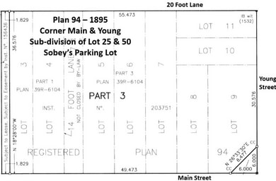
The corner of Main and Young underwent a major change in 1895 when a new plan for sub-dividing Lots 25 and 50 was implemented. Plan 94 was documented by surveyor Henry Wickstead and registered July 23, 1895. Most of the land involve from both Lot 50 and Lot 25 was owned at that time by John Edward Proctor.
The sketch at right shows the sub-division of lots in the south-east section of the area covered by in Plan 94, at the corner of Main and Young. We are concerned with Lots 8 and 9 at the corner, but also to some degree with Lots 10 and 11 north up Young Street to the 20-foot lane. Lots 7, 6 and 5 going west on Main Street will also be interesting, up to the 14-foot lane. Today, we can think of these lots making up the parking lot for the Sobey’s grocery store.
The sketch at right shows the sub-division of lots in the south-east section of the area covered by in Plan 94, at the corner of Main and Young. We are concerned with Lots 8 and 9 at the corner, but also to some degree with Lots 10 and 11 north up Young Street to the 20-foot lane. Lots 7, 6 and 5 going west on Main Street will also be interesting, up to the 14-foot lane. Today, we can think of these lots making up the parking lot for the Sobey’s grocery store.
During the 1880s, business activity developed to the west from the corner of Main Street with two business blocks built in the area of 28 and 30 Main Street. At the corner, evidence is scarce, but we do know that by the late 1890s, there was a brick building on the corner which supported butchers David Brooks and David Covell. In modern terms, we would call this 2 Main Street.
Then, in January 1904, the brick building on the corner was destroyed by fire. John Edward Proctor was now over 70 and was disposing of his extensive real estate holdings. The 1890s had been brutal for the Proctor fortune due to the loss of all of this ships in a terrible hurricane in the fall of 1893. This disaster knocked the wind out of the old man and his son Charles began to take over much of the business.
The property at Main and Young would go to Charles Russell Weller Proctor (1871-1930) who was only in his twenties, but was proving to have a head for business, like his father. He righted the ship of the family business and ensured a comfortable future for the family.
Then, in January 1904, the brick building on the corner was destroyed by fire. John Edward Proctor was now over 70 and was disposing of his extensive real estate holdings. The 1890s had been brutal for the Proctor fortune due to the loss of all of this ships in a terrible hurricane in the fall of 1893. This disaster knocked the wind out of the old man and his son Charles began to take over much of the business.
The property at Main and Young would go to Charles Russell Weller Proctor (1871-1930) who was only in his twenties, but was proving to have a head for business, like his father. He righted the ship of the family business and ensured a comfortable future for the family.
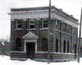
One of the deals he made was with the Standard Bank of Canada which had been located across the intersection on Prince Edward Street since 1883. A new building was constructed at the corner of Main and Young and the bank moved into their fancy new digs on February 24, 1905. A series of leases for this property were provided to the Standard Bank of Canada by Charles Proctor. This substantial building with the elegant entrance would become a fixture in Brighton and the place many residents did their banking, down through generations. In fact, this historian was taken there in the early 1960s to open his first bank account.
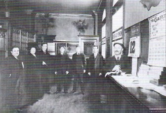
The picture to the left was taken inside the Standard Bank about 1910. The gentleman at the far left was Charles R. W. Proctor, the manager of the bank. To his left was Francis Marshall, then W. B. Purtelle. To his left, the three young fellows were bank clerks Mr. Haviland, Art Jones, D.B. Blacklock. The fellow on the right was Burton Becker, the owner of the popular store called Becker’s Bazaar, just across the street.
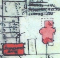
Charles Proctor was the manager of the Standard Bank for several years and had a very easy commute. He and his family lived in a large brick house on Young Street just north of the bank. There are few picture of this house but the Brighton Fire Map of 1911 shows the house as a large pink structure north of the bank. In the 1920s, Charles Proctor moved his family to Edmonton where he also worked as a bank manager. Illness caused him to come back home and he passed away at Millbank in 1930.
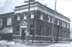
The bank building underwent a major expansion in 1922 when it was doubled in size (see picture at left). Bank staff were relocated to the east side of the building to take advantage of the windows along Young Street, which made for a brighter and much more pleasant workplace.
Another major change happened in 1928 when the Standard Bank merged with the Canadian Bank of Commerce, with the former giving way to the latter. That is how the name on the building became the Canadian Bank of Commerce.
Another major change happened in 1928 when the Standard Bank merged with the Canadian Bank of Commerce, with the former giving way to the latter. That is how the name on the building became the Canadian Bank of Commerce.
To the west up Main Street, William Charles Butler had acquired several sub-divided lots of Plan 94 from John E. Proctor and proceeded to build a commercial building to house numerous businesses. He passed this along to his sons, Edward and Malcolm and they also acquired land to the north in order to establish a boat building business. Butler’s Boat Shop was accessed off Young or Sanford Streets.
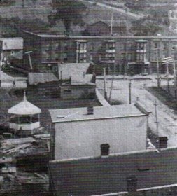
This picture, taken before 1904 from the town of the Town Hall, shows the old building still there on the corner, before the fire and the construction of the Standard Bank building. The Butler Block is the light-colored building separated from the corner by open space and a gazebo. The Butler Boat Shop would have been to the left off this picture.
This picture, taken before 1904 from the town of the Town Hall, shows the old building still there on the corner, before the fire and the construction of the Standard Bank building. The Butler Block is the light-colored building separated from the corner by open space and a gazebo. The Butler Boat Shop would have been to the left off this picture.
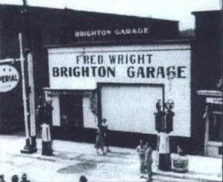
By 1913, the young Butler brothers addressed the growing presence of automobiles by establishing a garage and gas station on Main Street immediately south of their boat shop. The address would be 14 Main Street.
The original building was made of tin and there was one gas pump located out front, right on the street. This was the habit in the early days of automobiles. Drivers could swing over to the side of the street and fill up with gas.
The Butlers moved father up Main Street but the gas station continued here with Fred Wright as the owner and operator. This picture of the Brighton Garage was taken about 1930 and indicates how the gas pumps had developed but were still on the side of the street. Issues of public safety and traffic congestion on the main street would eventually create the modern form of a gas station where cars drive off the street into a row of gas pumps.
We might note that the Brighton Garage was a favorite spot for Ben Kerr, the notorious rum-rummer who took up residence at Presqu’ile for a year or so in the later 1920s. He like to bring his fancy car here for service and he sometimes had the mechanic from Brighton Garage come out to Presqu’ile to service his custom-made rum-running boat, Pollywog. Apparently, he liked the service at Wright’s Garage. Mainly, he liked the fact that the fellows at the garage were discrete and did not make a fuss over so famous a fellow in their midst. He felt safe in Brighton.
The original building was made of tin and there was one gas pump located out front, right on the street. This was the habit in the early days of automobiles. Drivers could swing over to the side of the street and fill up with gas.
The Butlers moved father up Main Street but the gas station continued here with Fred Wright as the owner and operator. This picture of the Brighton Garage was taken about 1930 and indicates how the gas pumps had developed but were still on the side of the street. Issues of public safety and traffic congestion on the main street would eventually create the modern form of a gas station where cars drive off the street into a row of gas pumps.
We might note that the Brighton Garage was a favorite spot for Ben Kerr, the notorious rum-rummer who took up residence at Presqu’ile for a year or so in the later 1920s. He like to bring his fancy car here for service and he sometimes had the mechanic from Brighton Garage come out to Presqu’ile to service his custom-made rum-running boat, Pollywog. Apparently, he liked the service at Wright’s Garage. Mainly, he liked the fact that the fellows at the garage were discrete and did not make a fuss over so famous a fellow in their midst. He felt safe in Brighton.
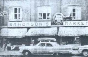
In 1919, a new business block was built in the empty space immediately west of the bank. It was built by the Proctor family and would occupy the addresses from 4 through 12 Main Street. In fact, the building was originally organized as five separate stores and many different businesses would use these spaces, changing very often.
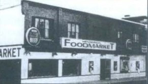
Popular vendors might be recalled, such as Ralph Cheer’s Restaurant and Ice Cream Parlor, and later, the Big Three Restaurant. There were many grocery stores here over the decades, including Thomson’s Food Market from 1926 to 1947, Brighton Food Market from 1950 to 1967 and, of course, Henderson’s Red & White from 1967 to 1980 when there was a fire. After this, the grocery store here was an I.G.A.
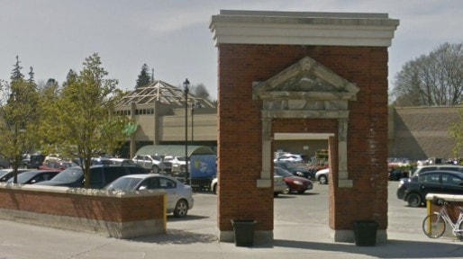
The corner of Main and Young underwent another dramatic change in 2003 when the land between Main and Sanford Streets and east of the laneway was brought together to form a large grocery store. Today, we see the Sobey’s store set well back from the corner, with the parking lot between the building and Main Street.
Out at the street, on the corner, part of the entrance to the old bank building is displayed in a brick structure. The date 1905 shows very clearly on the display, referring to the arrival of the Standard Bank of Canada at this corner. It seems a fitting tribute.
Seen from a historical standpoint, it is interesting to note that the Sobey’s building is located more or less where the original business here, the Sanford Hotel, stood for several decades in the 1800s, backing onto Sanford Street. Mr. Sanford was intent on leaving lots of space out front of his hotel for stage coach drivers to swing their teams around as they came and went. In the modern day, we must accommodate all those cars and provide the utmost convenience for shoppers.
As a result, we have a parking lot along a large section of Main Street. As a user of the facility, this historian can only say that shopping here is very convenient.
Out at the street, on the corner, part of the entrance to the old bank building is displayed in a brick structure. The date 1905 shows very clearly on the display, referring to the arrival of the Standard Bank of Canada at this corner. It seems a fitting tribute.
Seen from a historical standpoint, it is interesting to note that the Sobey’s building is located more or less where the original business here, the Sanford Hotel, stood for several decades in the 1800s, backing onto Sanford Street. Mr. Sanford was intent on leaving lots of space out front of his hotel for stage coach drivers to swing their teams around as they came and went. In the modern day, we must accommodate all those cars and provide the utmost convenience for shoppers.
As a result, we have a parking lot along a large section of Main Street. As a user of the facility, this historian can only say that shopping here is very convenient.