Introduction
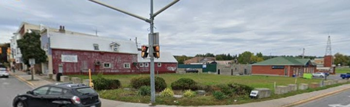
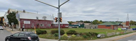
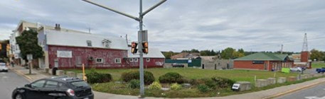
The north-east corner of Elizabeth and Prince Edward Streets has been an empty lot since 2006 when the last gas station was removed. A new building was built in 1991 at the corner of Alice Street, at the east end of this area, being initially a drug store and now a pet store. However, this area has an interesting history which only comes to light after some serious digging into land records, family histories and local history books. This project will try to make sense if it all.
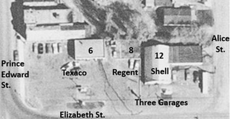
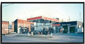
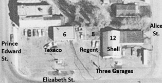
In the 1960s and for several decades, there were three auto-related businesses here. The Texaco station was on the Prince Edward Street corner at 6 Elizabeth Street. The Regent station was in the middle at 8 Elizabeth Street. On the corner of Alice Street was the Shell station, at 12 Elizabeth Street. The Regent station was sold to Texaco in 1962 and the Texaco station expanded. The Shell station was removed in 1991 and a new building built at the corner of Alice Street, initially hosting a drug store but in 2006 it became Pet Valu.
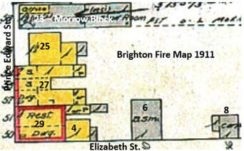
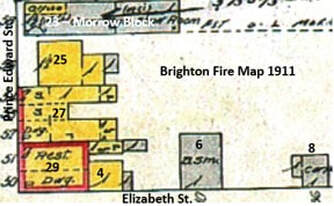
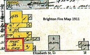
The 1911 Brighton Fire Map shows the buildings on the corner at a much earlier time. On Prince Edward Street, #25 was a house made into a restaurant and No. 29 hosted a restaurant as well, although the building was large enough to host several businesses in separate units. The building at 27 Prince Edward Street had three units, north, middle and south, with two levels, so hosted numerous offices and businesses. Down Elizabeth Street, there are three buildings at this time. No. 4 is a tinsmith’s shop, #6 is a blacksmith’s shop recently converted into a car paint shop. There was a carpenter’s shop in the next building at 8 Elizabeth St.
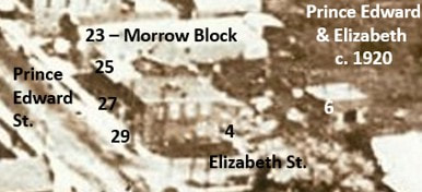
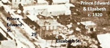
This snip of a 1920s aerial photo of the town provides a fuzzy representation of the structures at that time. We can see that the building at 29 Prince Edward Street as the largest in this area.
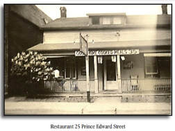
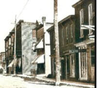
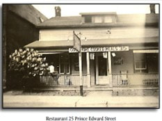
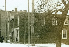
Early on, just south of the Morrow Block (23 Prince Edward St.) was 25 Prince Edward Street which was initially a regular frame house but later made into a very popular restaurant. There was a fire and a two-story brick commercial building was built there. The next building south, #27, was initially multiple small frame structures replaced with another brick commercial building after a fire. We can see these structures at the edge of photos of Prince Edward Street.
|
|
In order to complete the analysis of the properties at this corner, we need to look at the three Prince Edward Street addresses of #15, #27 and # 29. Then we will deal with the Elizabeth Street properties.
25 to 29 Prince Edward Street
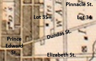
The land at the north-east corner of Dundas and Elizabeth Streets is in the farm south-west corner of the larger Lot 35, Concession A. The Patent from the Crown for all 200 acres of lot 35, Conc A was granted to Ann Marsh in 1825. Let’s remember that the border between the old Murray and Cramahe Townships was Prince Edward and Young Streets, so the land we are dealing with was on the east, or Murray side.
Ann McArthur (1771-1862) was 54 years of age when she obtained lot 35, but was already a prominent person in the community at the border of Murray and Cramahe Townships. She was born at Kinderhook, Columbia County, New York, near the Hudson River. Her family moved north as Loyalists and settled in Thurlow Township, at what was initially called Singleton’s corners and would later be Belleville.
Ann married Captain George Singleton in 1788, after he had been at the mouth of Singleton’s Creek for a few years conducting an active trading system with the Indigenous people to the north. Ann gave birth to a son, John, in January 1789. However, tragedy struck the family when George Singleton died of a fever while on the annual trip to Montreal. Each year they took the furs they had collected to Montreal and obtained more trade goods. George Singleton died near Bath and the other travelers came back home.
In 1791, the widow Ann Singleton married Alexander Chisholm, who had been an army buddy of George Singleton as well as a partner in trade. Ann would have five children with Alexander Chisholm as both Ann and Alexander parleyed their significant land grants into prosperity for their family. Alexander Chisholm wrote petitions begging for a grant of land at the mouth of what would become the Moira River, but his efforts were thwarted by the rise to prominence of John Walden Meyers who had strong supporters in high places due to his work as a spy for the British during the American War of Independence.
Ann married Captain George Singleton in 1788, after he had been at the mouth of Singleton’s Creek for a few years conducting an active trading system with the Indigenous people to the north. Ann gave birth to a son, John, in January 1789. However, tragedy struck the family when George Singleton died of a fever while on the annual trip to Montreal. Each year they took the furs they had collected to Montreal and obtained more trade goods. George Singleton died near Bath and the other travelers came back home.
In 1791, the widow Ann Singleton married Alexander Chisholm, who had been an army buddy of George Singleton as well as a partner in trade. Ann would have five children with Alexander Chisholm as both Ann and Alexander parleyed their significant land grants into prosperity for their family. Alexander Chisholm wrote petitions begging for a grant of land at the mouth of what would become the Moira River, but his efforts were thwarted by the rise to prominence of John Walden Meyers who had strong supporters in high places due to his work as a spy for the British during the American War of Independence.
Alexander and Ann Chisholm decided to try elsewhere and moved to the north shore of Presqu’ile Bay. They built saw and grist mills at the mouth of the creek flowing into the bay, which later would be called Butler Creek. They were squatters on the land which had been designated as government reserve, but they did manage to obtain a lease. Alexander Chisholm died in 1808 without achieving his dream of creating a town to carry his name, but Ann would carry on with the busy job of managing all the family’s land grants – and founding the town of Brighton.
Around 1810, Ann married Cyrus Marsh, who was a son of Mathias Marsh, part of the large family of Col. William Marsh, a prominent loyalist. Until her death around 1862, Ann Mash would be engaged in many land transactions in the immediate area of Brighton. The grant of Lot 35 solidified the position of her son, John Singleton and herself as founders of the new village of Brighton when it was established in 1831. The initial home for this family was on the south side of Dundas Street, on the corner of Alice Street and a more modern home was built by later generation to the north on Singleton Street.
Around 1810, Ann married Cyrus Marsh, who was a son of Mathias Marsh, part of the large family of Col. William Marsh, a prominent loyalist. Until her death around 1862, Ann Mash would be engaged in many land transactions in the immediate area of Brighton. The grant of Lot 35 solidified the position of her son, John Singleton and herself as founders of the new village of Brighton when it was established in 1831. The initial home for this family was on the south side of Dundas Street, on the corner of Alice Street and a more modern home was built by later generation to the north on Singleton Street.
In 1834, Ann Marsh granted the west half of lot 35 to her son, John Singleton (1789-1837). He was a son of Capt. George Singleton and Ann McArthur, born in Thurlow Township. He was only a baby when his father died in 1789. Later, he came with his parents, now Alexander and Ann Chisholm, when they moved to Murray Township and was age 14 at the 1803 Census. In 1811 he married Margaret Canniff (1794-1886) a daughter of James C. Canniff and Elizabeth McBride. By 1815, the family had moved to Murray Township to be near his mother. They would have five children, George, Abraham, Melissa and Leonora.
In 1852, the Singleton family granted the west half of lot 35 to Abraham Singleton, a son of John and Margaret. There were several mortgages in a couple of years and in 1861 the Trust & Loan Co. sold the same land to Margaret Singleton. The next years, she passed it to her youngest child, daughter, Leonora Emily Singleton (1822-1909). Leonora remained single and was much involved in her mother’s extensive real estate dealings.
In 1863, Eliza A. Meade granted part of this area that would be Village Lot 14 to Clarissa E. Sutherland Clarissa Elizabeth Sutherland (1846-1904) was a daughter of William Sutherland and Amanda Marsh of Consecon. She remained single and came to Brighton to engage in business. A significant building was erected at the corner of Prince Edward and Elizabeth streets which would be a business block, providing space for many different commercial enterprises over the years.
In 1852, the Singleton family granted the west half of lot 35 to Abraham Singleton, a son of John and Margaret. There were several mortgages in a couple of years and in 1861 the Trust & Loan Co. sold the same land to Margaret Singleton. The next years, she passed it to her youngest child, daughter, Leonora Emily Singleton (1822-1909). Leonora remained single and was much involved in her mother’s extensive real estate dealings.
In 1863, Eliza A. Meade granted part of this area that would be Village Lot 14 to Clarissa E. Sutherland Clarissa Elizabeth Sutherland (1846-1904) was a daughter of William Sutherland and Amanda Marsh of Consecon. She remained single and came to Brighton to engage in business. A significant building was erected at the corner of Prince Edward and Elizabeth streets which would be a business block, providing space for many different commercial enterprises over the years.
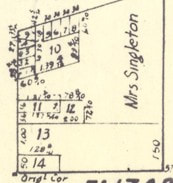
The 1866 Brighton Plan shows that the south side of this section of lot 35 had been divided into lots 13 and 14. Lot 14 was small and only covered the far south-west corner of the area, but lot 13 was larger, covering the land south of the Morrow Block and east to Alice Street. Leonora Singleton owned this property, Village Lot 13, when various buildings were built along the east side of Prince Edward Street, extending the busy business area from the main intersection. For a time there was a building here called the Bedal Block but it was destroyed by fire in 1898. Details are scarce about the exact occupants or events.
However, the next transaction for Village Lot 13 was in 1883 when the Will of Eliza A. Meade granted part of lot 13 to her children. Eliza Ann Singleton (1811-1897) was a sister of Leonora E. Singleton, married to Dr. Henry Meade. This transaction was in the family, although this researcher has not seen a transaction that passed the property from Leonora Singleton to Eliza Meade. In any case, we must assume that is what happened.
Later, in 1889, the Estate of Eliza Meade passed part of lot 13 to John S. Meade. This was John Singleton Meade (1840-1921), a son of Dr. Henry Meade and Eliza Ann Singleton. The next year, he passed the property to Lenora H. Duncan. This was Leonora Hellen Meade (1844-1933), a sister of John’s, married to Rev. Peter McLaren Duncan who conducted his ministry in both Colborne and Brighton.
In 1897 we also see a Quit Claim transaction where Matura Bedal released any claim on “that part said lot on which building used as photo gallery is situated”. Matura Tubbs (1817-1912) was the wife of Isaac Bedal and part of a large farming family near Smithfield. Brock & Co. Photo Gallery operated in 27 Prince Edward Street from 1881 to the fire in 1898.
Later, in 1889, the Estate of Eliza Meade passed part of lot 13 to John S. Meade. This was John Singleton Meade (1840-1921), a son of Dr. Henry Meade and Eliza Ann Singleton. The next year, he passed the property to Lenora H. Duncan. This was Leonora Hellen Meade (1844-1933), a sister of John’s, married to Rev. Peter McLaren Duncan who conducted his ministry in both Colborne and Brighton.
In 1897 we also see a Quit Claim transaction where Matura Bedal released any claim on “that part said lot on which building used as photo gallery is situated”. Matura Tubbs (1817-1912) was the wife of Isaac Bedal and part of a large farming family near Smithfield. Brock & Co. Photo Gallery operated in 27 Prince Edward Street from 1881 to the fire in 1898.
The area experienced a devastating fire in February 1898:
“On Saturday morning, about 2 o’clock, fire broke out in the brick block, owned by Mrs. Sutherland and occupied by Mr. A.D. Martin, for a bake shop with living rooms in the upper flat, also a harness shop occupied by Mr. D. Rogers with Mr. Doxsee as manager. The fire worked its way to the photograph gallery, occupied by Brock & Co., Miss Alexander’s shop and finally into Mrs. Bedal’s house. The heat from the fire broke the glass in the windows of the Webb block across the street. Nothing was saved and settlements were made to A.D. Martin, D. Rogers Harness Shop, and Miss Alexander Mercantile. Mrs. Bedal saved the greater portion of their contents. (25 to 29 Prince Edward Street)”
Buildings were rebuilt in better form after this fire and the Fire Map of 1911 suggests the structures that were there at that time.
“On Saturday morning, about 2 o’clock, fire broke out in the brick block, owned by Mrs. Sutherland and occupied by Mr. A.D. Martin, for a bake shop with living rooms in the upper flat, also a harness shop occupied by Mr. D. Rogers with Mr. Doxsee as manager. The fire worked its way to the photograph gallery, occupied by Brock & Co., Miss Alexander’s shop and finally into Mrs. Bedal’s house. The heat from the fire broke the glass in the windows of the Webb block across the street. Nothing was saved and settlements were made to A.D. Martin, D. Rogers Harness Shop, and Miss Alexander Mercantile. Mrs. Bedal saved the greater portion of their contents. (25 to 29 Prince Edward Street)”
Buildings were rebuilt in better form after this fire and the Fire Map of 1911 suggests the structures that were there at that time.
In 1922, Lenora H. Duncan sold the property in Lot 13 to Henry Meade (1851-1925), a son of Dr. Henry Meade and Eliza Ann Singlteon. His father, the revered doctor, had died in 1858, and Henry, or Harry, was engaged in managing the extensive real estate holdings of his parents. He sold this property quickly to James Hodge and moved to California. James Hodge (1870-1947) invested in this property while his sister, Mary Calabeck, was the proprietor of a restaurant at 25 Prince Edward Street from 1921 to 1932. At the time, he was living in Toronto.
Mr. Hodge held this investment for a decade, then, in 1932, sold it to John Vincent. John Robert Vincent (1864-1944) was a son of Stephen Vincent and Mary Matilda Scott, farmers at Conc A, Lot 35, on the east side of Brighton. He married Rosa Roblin in 1893 and they had two children, Evelyn and Kenneth. John Vincent was extremely active in business and commercial property development in the Prince Edward Street area of Brighton. He was involved in the apple business, often called a “Fruit dealer” but the records show he was involved in different enterprises, with not a little land speculation, as was common for folks who had ready money.
In April 1936, Rene McCallum (1895-1973) opened Rene’s Coffee Shop in the building at 25 Prince Edward Street. She was a daughter of Peter James McCallum and Elizabeth Ann Petch. She had been born at Crosshill in Waterloo County, Ontario, but the family would move to Toronto in the 1920s. Her father was a carpenter and builder and built a cottage at Presqu’ile around 1920. His son, and Rene’s brother, William John McCallum became directly involved in the expansion of Hotel Presqu’ile in partnership with Grant Quick. Rene married John Joseph Dickson in 1925 and their home was in Toronto until he died in 1932. Then, in April 1939 Rene’s Coffee Shop moved to the White House at the west end of Brighton.
|
|
In 1944, the Estate of John Vincent granted this property partly to his niece Marie McKinnon and partly to his nephew Donald Vincent. Mary Marie Vincent (1913-2004) was a daughter of Clarence Theodore Vincent and Della Permelia Rowley, so a sister of Donald Vincent. She married Hilton Albert McKinnon in 1932 and lived in Brighton in the 1940s, moving to Toronto in the 1950s. Donald Theodore Vincent (1909-1983) was a son of Clarence Theodore Vincent and Della Permelia Rowley, so a nephew of John Vincent and executor for his estate. He married Dorothy Simpson in 1932 and initially farmed east of Brighton. He drove truck for a while but in the 1940s became heavily involved in business in Brighton. He was known for running a dry cleaning business, first in the commercial buildings on the east side of Prince Edward Street where Northumberland Plaza is today, but then in a much larger facility just north of the railway tracks.
A year later, Donald Vincent and Marie McKinnon sold part of lot 13 to Mary M. McKinnon and Hilton A. McKinnon, basically Marie and her husband. Then, in 1947, Marie McKinnon sold it to Frank & Margaret Chatterson. Francis R. “Frank” Chatterson (1888-1948) was a son of Munroe Chatterson and Ida Outendyke of Presqu’ile Point. He married Myrtle May Brown in 1915 in Colborne and after she died in 1930, he married Margaret Jean Bailey.
In 1948, Margaret Chatterson sold to Myrtle M. Montgomery and in 1952, she sold to Fred and Wanda Brown, a family in Toronto. Then, in 1961, Fred and Wanda Brown sold the property to Texaco Canada Limited.
These buildings had many commercial tenants over the years and the all are listed in Susan Brose’s wonderful book “History of Brighton Businesses” for those who are interested.
A year later, Donald Vincent and Marie McKinnon sold part of lot 13 to Mary M. McKinnon and Hilton A. McKinnon, basically Marie and her husband. Then, in 1947, Marie McKinnon sold it to Frank & Margaret Chatterson. Francis R. “Frank” Chatterson (1888-1948) was a son of Munroe Chatterson and Ida Outendyke of Presqu’ile Point. He married Myrtle May Brown in 1915 in Colborne and after she died in 1930, he married Margaret Jean Bailey.
In 1948, Margaret Chatterson sold to Myrtle M. Montgomery and in 1952, she sold to Fred and Wanda Brown, a family in Toronto. Then, in 1961, Fred and Wanda Brown sold the property to Texaco Canada Limited.
These buildings had many commercial tenants over the years and the all are listed in Susan Brose’s wonderful book “History of Brighton Businesses” for those who are interested.
4 Elizabeth Street
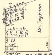
The addresses of 4, 6 and 8 Elizabeth Street were along the north side of Elizabeth Street in what is now an empty lot. However, back in the day, and even before the gas stations, this was a busy commercial area. The 1866 Brighton Plan shows that the south side of this section of lot 35 had been divided into lots 13 and 14. Lot 14 was small and only covered the far south-corner of the area, but lot 13 was larger, covering the land south of the Morrow Block and east to Alice Street.
The history of these properties is the same up to the 1850s when the Singleton family still owned large parts of Lot 35. In 1852, the Singleton family granted the west half of lot 35 to Abraham Singleton, a son of John and Margaret. There were several mortgages in a couple of years and in 1861 the Trust & Loan Co. sold the same land to Margaret Singleton. The next years, she passed it to her youngest child, daughter, Leonora Emily Singleton (1822-1909). Leonora remained single and was much involved in her mother’s extensive real estate dealings.
There was a disastrous fire that destroyed the buildings along Prince Edward Street to the Elizabeth Street corner. Mrs. Sutherland had built the building at 29 Elizabeth Street and, in order to continue in business, she took a mortgage from Isaac O. Proctor. The next transaction was in 1918 when Mr. Proctor sold property in lot 13 to Charles D. Taft for $1,200. He sold it two years later to Isaac M. Snider.
Isaac Marshall Snider (1857-1940) was from Frankford, a son of George Clarence Snider and Mary Moynes. He married Jenny Berry in 1882 and took on the trade of tinsmith. From 1887, Mr. Snider plied his trade in Brighton, occupying shops in various location, several on Prince Edward and Main Streets in Brighton. He had been in the building at 29 Prince Edward Street for a short time when he moved into the space at 4 Elizabeth Street. He would occupy 4 Elizabeth Street until 1922.
Then, in 1929, 4 Elizabeth Street was granted to Mary L. Sundberg and Ruth B. Atkins for $1. Mary Louise Snider (1883-1952) was Isaac M. Snider’s oldest daughter and she was married to Paul Sundberg. Ruth Berry Snider (1895-1976) was the youngest of Isaac Snider’s children and she was married to Clarence Harold Atkins. Clarence Atkins was a son of John Atkins and Marian Matilda Newbon, residents of New York City who came to Presqu’ile Point for summer holidays, starting around 1900. Clarence’s brother, Jack, was so enamored of the area that he decided to farm and live permanently on Presqu’ile Point. Clarence had served with the 107th Infantry during WWI before his marriage to Ruth Berry Snider, then he was working in a paper plant in Massachusetts. The fact that Clarence married a Brighton girl should not be a surprise, since he and his siblings spent summers at Presqu’ile through their teen years.
The ownership of the property is one thing, but these were commercial spaces that were often rented or leased by the owner, so the land records don’t provide everything we need. Susan Brose’s book “History of Brighton Businesses” helps complete the picture. It shows that 4 Elizabeth Street was a tinsmith shop from 1911 and Isaac Snider as a Tinsmith and Sheet Metal Works from 1922 to 1927. From 1928 to 1933 it was Alex Watson, a very experienced shoe maker. From 1933 to 1935 John Dixon’s Boot and Shoe Repair shop was here.
In 1944, Mary and Ruth sold Lot 14, including 4 Elizabeth Street, to George Lim who held it until 1961 when he sold to Norman J. Bertram. In a few months, Mr. Bertram sold to Texaco Canada Limited.
In 1980, the service station and gas bays at the corner were still under Texaco, but by 1989 it became an ESSO station, which it remained until it closed in 2003. The structure was demolished in 2006, leaving the empty lot we see today.
Then, in 1929, 4 Elizabeth Street was granted to Mary L. Sundberg and Ruth B. Atkins for $1. Mary Louise Snider (1883-1952) was Isaac M. Snider’s oldest daughter and she was married to Paul Sundberg. Ruth Berry Snider (1895-1976) was the youngest of Isaac Snider’s children and she was married to Clarence Harold Atkins. Clarence Atkins was a son of John Atkins and Marian Matilda Newbon, residents of New York City who came to Presqu’ile Point for summer holidays, starting around 1900. Clarence’s brother, Jack, was so enamored of the area that he decided to farm and live permanently on Presqu’ile Point. Clarence had served with the 107th Infantry during WWI before his marriage to Ruth Berry Snider, then he was working in a paper plant in Massachusetts. The fact that Clarence married a Brighton girl should not be a surprise, since he and his siblings spent summers at Presqu’ile through their teen years.
The ownership of the property is one thing, but these were commercial spaces that were often rented or leased by the owner, so the land records don’t provide everything we need. Susan Brose’s book “History of Brighton Businesses” helps complete the picture. It shows that 4 Elizabeth Street was a tinsmith shop from 1911 and Isaac Snider as a Tinsmith and Sheet Metal Works from 1922 to 1927. From 1928 to 1933 it was Alex Watson, a very experienced shoe maker. From 1933 to 1935 John Dixon’s Boot and Shoe Repair shop was here.
In 1944, Mary and Ruth sold Lot 14, including 4 Elizabeth Street, to George Lim who held it until 1961 when he sold to Norman J. Bertram. In a few months, Mr. Bertram sold to Texaco Canada Limited.
In 1980, the service station and gas bays at the corner were still under Texaco, but by 1989 it became an ESSO station, which it remained until it closed in 2003. The structure was demolished in 2006, leaving the empty lot we see today.
6 Elizabeth Street
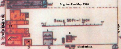
This snip of the 1926 Brighton Fire Map shows the three buildings on the north side of Elizabeth Street at that time. A small structure immediately east of 29 Prince Edward Street was 4 Elizabeth Street and the larger building a little to the east, was 6 Elizabeth Street. For some time, there was another rather small place farther to the east and that was 8 Elizabeth Street.
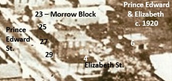
This snip from the 1920 aerial picture of downtown Brighton shows the large 29 Prince Edward Street at the corner, then smaller, unclear space to the east and one larger structure to the east which was #6.
The building at 6 Elizabeth Street hosted Wellington Hare’s blacksmith shop from 1890 to 1919, a long time for one business at one location. From 1920 until 1926, it hosted an auto paint shop.
The building at 6 Elizabeth Street hosted Wellington Hare’s blacksmith shop from 1890 to 1919, a long time for one business at one location. From 1920 until 1926, it hosted an auto paint shop.
There were gas stations in this area of Elizabeth Street that co-existed with the old buildings. As early as 1924, Stuart Gunyo operated a station on the street in Lot 13, which we might expect could be called 8 Elizabeth Street. It was described as follows “A new filling station on Elizabeth opposite the Craig Livery. The station is of the newest and most approved style having one of the largest and best pumps and covered driveways.”
This snip of the aerial phots in the 1960 shows the early arrangement of gas stations on the north side of Elizabeth Street. The Texaco station is called 6 Elizabeth Street and there is a small Regent station to the east called 8 Elizabeth Street. The Regent station closed and the property was absorbed by the Texaco station, so the address was discontinued.
This snip of the aerial phots in the 1960 shows the early arrangement of gas stations on the north side of Elizabeth Street. The Texaco station is called 6 Elizabeth Street and there is a small Regent station to the east called 8 Elizabeth Street. The Regent station closed and the property was absorbed by the Texaco station, so the address was discontinued.
|
|
8 Elizabeth Street
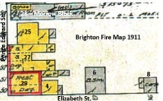
The history of 8 Elizabeth Street goes back farther than one might think. It has the same history as others in the area until 1924 when Leonora H. Duncan sold a small piece of Lot 13 to Alfred and Stuart Gunyo. The 1911 Fire Map shows a structure on Elizabeth St. in the middle of lot 13, labelled as “carp.” The property was owned by Leonora H. Duncan and it may have been Finlay Clark who is one of many carpenters in Brighton at this time.
Alfred Gunyo (1868-1935) was born in Brighton, a son of Asa Gunyo and Phoebe Quick. He married Jennie Riley in 1890 and was engaged mostly in the grocery business. Stuart Alfred Gunyo (189901956) was a son of Alfred and married Nancy Latta in 1921 and also worked as a merchant in Brighton. These two businessmen acquired the property at 8 Elizabeth Street in 1924 and built an automobile service station. In 1928, the station was sold to John F. Lockwood.
John Frederick Lockwood (1871-1933), known as Fred, was a son of Jonas Lockwood and Emily Catherine Walker, born in East Camden St., Lennox & Addington County. He married Ella May Van Luven in 1892 and they had only one child, Lorne Adelbert Lockwood (1903-1981) who worked with his father at the garage on Elizabeth Street.
John Frederick Lockwood (1871-1933), known as Fred, was a son of Jonas Lockwood and Emily Catherine Walker, born in East Camden St., Lennox & Addington County. He married Ella May Van Luven in 1892 and they had only one child, Lorne Adelbert Lockwood (1903-1981) who worked with his father at the garage on Elizabeth Street.
The Lockwood Service Station operated successfully for a few years, even taking a mortgage and discharging it as required. Then, disaster struck. Here is a newspaper report of the events on December 30, 1933.
"Two men were burned to death here Saturday night when fire broke out in a service station. The deceased are Royal Cummings, a 16-year-old and Frederick Lockwood, the 62-year-old owner of the service station. Ernest Best 40, and Willard Tackaberry, 27, were in the service station when the fire occurred and escaped with minor burns. Best threw Tackaberry to safety through a window, and then crawled out after him. A pail of oil was placed on a stove for the purpose of thinning it. The oil boiled over and fell into the stove, causing an explosion. In a few seconds the whole station was enveloped in flames. Best tried to open the door, but the pressure of the heated air kept it closed tightly; Lockwood and Cummings were attempting to put out the fire. When Best found it impossible to open the door he forced Tackaberry, half dazed with smoke, through the window and then followed him. Best again attempted to open the door this time front the outside, to rescue Lockwood and Cummings but his efforts proved in vain. Others arrived and the door was finally forced open. The bodies of Cumming and Lockwood were found on the blazing floor, burned beyond recognition. They were trying to escape through the door, as their bodies were found beside it. The Brighton fire department succeeded in extinguishing the flames, but the service station building is practically a total loss. The fire spread so rapidly that the whole building was doomed within ten minutes. Viewing the ruins a galvanized iron structure, the outer walls are still standing, but the interior is nothing but a charred mass of ruins. (8 Elizabeth Street)"
"Two men were burned to death here Saturday night when fire broke out in a service station. The deceased are Royal Cummings, a 16-year-old and Frederick Lockwood, the 62-year-old owner of the service station. Ernest Best 40, and Willard Tackaberry, 27, were in the service station when the fire occurred and escaped with minor burns. Best threw Tackaberry to safety through a window, and then crawled out after him. A pail of oil was placed on a stove for the purpose of thinning it. The oil boiled over and fell into the stove, causing an explosion. In a few seconds the whole station was enveloped in flames. Best tried to open the door, but the pressure of the heated air kept it closed tightly; Lockwood and Cummings were attempting to put out the fire. When Best found it impossible to open the door he forced Tackaberry, half dazed with smoke, through the window and then followed him. Best again attempted to open the door this time front the outside, to rescue Lockwood and Cummings but his efforts proved in vain. Others arrived and the door was finally forced open. The bodies of Cumming and Lockwood were found on the blazing floor, burned beyond recognition. They were trying to escape through the door, as their bodies were found beside it. The Brighton fire department succeeded in extinguishing the flames, but the service station building is practically a total loss. The fire spread so rapidly that the whole building was doomed within ten minutes. Viewing the ruins a galvanized iron structure, the outer walls are still standing, but the interior is nothing but a charred mass of ruins. (8 Elizabeth Street)"
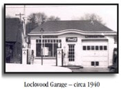
Lorne Lockwood, the only son of Fred, stepped in to rebuild the service station quickly, arranging a lease with in 1934 with Sun Oil Company. The picture we have of the Lockwood garage in circa 1940 refers to Lorne Lockwood who ran the station for until 1945.
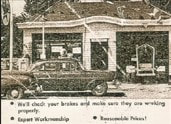
After 1945, the business was known as “Regent Service Station and Car Wash”, operated by K. N. Freeman, then Percy Carr from 1949 to 1952, Freeman again until September 1953, then Albert Hubbs 1953 and 1954, then Jim Browning until 1956. It operated until 1957 under the Regent name, with Gordon Kemp the operator, then, in 1962, it became a Texaco station, still with Mr. Kemp as operator. Another picture of this business is labelled “Kemp’s Garage”
Albert Jackson then took over this Texaco station and would be the operator until 1966 when this smaller station was merged with the much larger Texaco station on the corner, and it became one business. Thus, 8 Elizabeth Street was no longer in use.
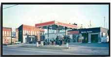
In 1980, the service station and gas bays at the corner were still under Texaco, but by 1989 it became an ESSO station, which it remained until it closed in 2003. The structure was demolished in 2006, leaving the empty lot we see today.
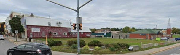
12 Elizabeth Street
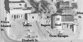
Today, 12 Elizabeth Street hosts a pet supplies store, on the north-west corner of Elizabeth and Alice Streets. Back in the 1960s, it hosted one of three gas stations, garage businesses on the north side of Elizabeth Street. This snip of the 1960s aerial photo shows the Texaco station at the corner of Prince Edward and Elizabeth Streets which was 6 Elizabeth Street, and the Regent station just east of there at 8 Elizabeth Street. Immediately east of the Regent station is the Shell station which is 12 Elizabeth Street, extending to the western edge of Alice Street.
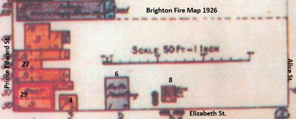
If we go back in time, the 1926 Brighton Fire Map shows the buildings in the area at that time. It clearly shows that there were several commercial structures along Prince Edward Street to the corner of Elizabeth Street. There were three structures on the north side of Elizabeth Street labelled as 4, 6 and 8 Elizabeth Street, at this time small buildings supporting tinsmiths and carpenters. However, there were no structures at all in the eastern part of Lot 13 up to Alice Street. The development of this eastern part of Lot 13 was later than the west end.
The history of the east end of Lot 13 follows the rest of the properties in the lot until 1889 when the estate of Dr. Henry Meade (who died in 1858) was granted to John Singleton Meade (1940-1921), the eldest child of Dr. Meade and Eliza Ann Singleton. Long before this, he had moved to Colorado and later would live in California, so these transactions were handled by lawyers. Dr. Meade’s estate was extremely complex and there is little documentation for his death, which may explain why his executors were still dealing with land issues three decades after his demise.
In 1897, John S. Meade granted this land to his sister, Lenora H. (Meade) Duncan (1844-1933) who held it until 1922 when it was sold to Henry Meade, Lenora’s younger brother. He sold this property quickly to James Hodge and moved to California. James Hodge (1870-1947) invested in this property while his sister, Mary Calabeck, was the proprietor of a restaurant at 25 Prince Edward Street from 1921 to 1932. At the time, he was living in Toronto.
Then, in 1927, James Hodge sold the property to Donald C. Matthews. At this point we can expect that the general description of “Part Lot 13” actually refers to the eastern part up to Alice Street. Donald Conacher Matthews (1859-1930) was a son of Isaac Matthews and Sylvia Goulding, born and raised in the Lakeport area of Haldimand Township. He married Catherine Pomeroy in Castleton in 1879 and was an apple dealer for many years. Don Matthews built a new service station building which opened for business in June 1927. He also acquired a Ford Dealership to enhance the profile of the gas station and repair shop.
In 1897, John S. Meade granted this land to his sister, Lenora H. (Meade) Duncan (1844-1933) who held it until 1922 when it was sold to Henry Meade, Lenora’s younger brother. He sold this property quickly to James Hodge and moved to California. James Hodge (1870-1947) invested in this property while his sister, Mary Calabeck, was the proprietor of a restaurant at 25 Prince Edward Street from 1921 to 1932. At the time, he was living in Toronto.
Then, in 1927, James Hodge sold the property to Donald C. Matthews. At this point we can expect that the general description of “Part Lot 13” actually refers to the eastern part up to Alice Street. Donald Conacher Matthews (1859-1930) was a son of Isaac Matthews and Sylvia Goulding, born and raised in the Lakeport area of Haldimand Township. He married Catherine Pomeroy in Castleton in 1879 and was an apple dealer for many years. Don Matthews built a new service station building which opened for business in June 1927. He also acquired a Ford Dealership to enhance the profile of the gas station and repair shop.
Don Matthews passed away on January 9, 1930 and a year later, his son, Fred Matthews, sold the business to Charles L. Todd for $4,000. Charles Leslie Todd (1897-1940) was a son of Edward Todd and Ellen Ingram, born in Rawdon Township. He was living near Hoards Station in Seymour Twp. in 1923 when he married Marjorie Anne McGee (1900-1942), daughter of George H. McGee and Elizabeth M. Lowe. Charles Todd’s Shell station operated until 1934 when H. Sayers took over, soon replaced by George McGee, Charles Todd’s father-in-law. Then, in 1942, the Estate of Charles L. Todd granted the property at 12 Elizabeth Street to George H. McGee who was a farmer in Rawdon Township and executor for the estate of his daughter, Marjorie Anne (McGee) Todd.
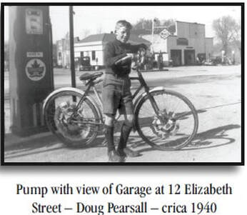
In 1945, George H. McGee granted the property to his son, Reginald McGee. A few months later, George and Reginald McGee sold to H. Douglas McColl. Hugh “Douglas” McColl (1900-1960) was a son of Samuel McColl & Ethel Maud Ames, from the Codrington area. He married Marjorie Olive Langdon in 1926 and was manager of Public Utilities for Brighton while being engaged in operation of the Shell service station at 12 Elizabeth Street.
A little more than a decade later, in 1956, Doug McColl sold the business to George G. Thorne. George Gordon Thorne (1931-1997) was a son of Fred Thorne & Marjorie Ruth Sprung, from the Hilton area. He married Margaret Anne McColl in 1953, she being a daughter of Hugh Douglas McColl and Ethel Ames. He would operate a Shell service station on the 401. Almost a decade later, in 1965, George Thorne sold the Shell station to Ron W. Smith who made an agreement with Shell Canada Limited.
A little more than a decade later, in 1956, Doug McColl sold the business to George G. Thorne. George Gordon Thorne (1931-1997) was a son of Fred Thorne & Marjorie Ruth Sprung, from the Hilton area. He married Margaret Anne McColl in 1953, she being a daughter of Hugh Douglas McColl and Ethel Ames. He would operate a Shell service station on the 401. Almost a decade later, in 1965, George Thorne sold the Shell station to Ron W. Smith who made an agreement with Shell Canada Limited.
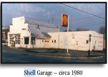
The municipality instituted a new plan for this property in June 1989 with R-Plan 38R-4681, referencing the land description from the recent sale to Mr. Smith. A few months later, Mr. Smith sold the property to a numbered company for $225,000. The description in a later release was “commencing at south-east angle of lot, westerly 110 feet, northerly 85 feet, easterly 110 feet, southerly 85 feet”.
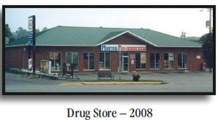
The old service station buildings were removed and a new building erected to support a drug store. Then, in 1998, a numbered company sold the property to Brighton Drugs Ltd. for $350,000. In 2002, Brighton Drug Ltd. sold the same property back to the same numbered company for a bit more money. Another sale between numbered companies edged the amount even higher in 2003, which established PharmaPlus in the building. In 2005, PharmaPlus moved to 1 Main Street PharmaSave continued for a time at 12 Elizabeth Street.
Within the next couple of years, the drug store moved across the street and occupied the lower floor at 19 Elizabeth Street, becoming PharmaChoice. The upstairs of the same building is 21 Elizabeth Street, the current home of the History Guy of Brighton. The building at 12 Elizabeth Street now hosted a pet supplies store called Pet Valu which is present at this writing in 2016.
The old service station buildings were removed and a new building erected to support a drug store. Then, in 1998, a numbered company sold the property to Brighton Drugs Ltd. for $350,000. In 2002, Brighton Drug Ltd. sold the same property back to the same numbered company for a bit more money. Another sale between numbered companies edged the amount even higher in 2003, which established PharmaPlus in the building. In 2005, PharmaPlus moved to 1 Main Street PharmaSave continued for a time at 12 Elizabeth Street.
Within the next couple of years, the drug store moved across the street and occupied the lower floor at 19 Elizabeth Street, becoming PharmaChoice. The upstairs of the same building is 21 Elizabeth Street, the current home of the History Guy of Brighton. The building at 12 Elizabeth Street now hosted a pet supplies store called Pet Valu which is present at this writing in 2016.
20 Elizabeth Street
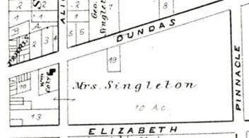
The next property is 20 Elizabeth Street which is the Fire Station. This is located at the south-west corner of the block bordered by Elizabeth Street on the south, Alice Street on the west, Dundas Street on the north and Pinnacle Street on the east. The Belden County Atlas map of 1878 shows that this 10-acre block was still owned by Mrs. Singleton, which in this case refers to Leonora Emily Singleton (1822-1909), the youngest child of John Singleton and Margaret Canniff. Leonora Singleton remained single and participated intensely in the real estate projects of her family, often exchanging properties with her mother and siblings.
The land transactions are very confusing in this period. However, it is clear that Margaret Singleton sold “the south part of the west half” of lot 35 to her daughter, Leonora, in 1861. Margaret had acquired large parts of lot 35 a few years before when another of her children, Abraham C. Singleton, took on the land from the others in the family but was not able to discharge several mortgages. Withing a few years, his mother had to come in and bail him out. The mortgages ended up with the Trust and Loan Company and, in 1861, Margaret Singleton bought the west half from Trust and Loan. Very quickly, Margaret passed some of that land to her youngest daughter, Leonora.
Leonora Singleton held this land until 1905 when she sold it to Henry Meade, the son of Dr. Henry Meade. The younger Henry Meade was trying to manage his father’s extensive real estate portfolio, along with his mother, but by the 19-teens, Henry was living in Toronto. In 1925, he would die in the Homewood Sanitorium in Guelph. So, in 1913, he was moving property along and one example was the block bounded by Elizabeth, Alice, Dundas and Pinnacle Streets.
Some of this land had been sold to William Coyle in the 1870s so he could set up his blacksmith shop on the south side of Dundas Street, east of Alice Street, near what is labelled as Lot 19 on the map. This worked well for Mr. Coyle because his family home was just across Alice Street in what is now the parking lot for the library and municipal office.
Leonora Singleton held this land until 1905 when she sold it to Henry Meade, the son of Dr. Henry Meade. The younger Henry Meade was trying to manage his father’s extensive real estate portfolio, along with his mother, but by the 19-teens, Henry was living in Toronto. In 1925, he would die in the Homewood Sanitorium in Guelph. So, in 1913, he was moving property along and one example was the block bounded by Elizabeth, Alice, Dundas and Pinnacle Streets.
Some of this land had been sold to William Coyle in the 1870s so he could set up his blacksmith shop on the south side of Dundas Street, east of Alice Street, near what is labelled as Lot 19 on the map. This worked well for Mr. Coyle because his family home was just across Alice Street in what is now the parking lot for the library and municipal office.
However, the bulk of the block was still unused in 1913 when Henry Meade sold 12 acres of land excluding the Coyle piece, to the Board of Education who build a school on the north side of Elizabeth Street.
The east corner of Alice and Elizabeth was empty until 1969 when the Board of Education sold 0.55 acres of land at the south-west corner of the block to the Village of Brighton.
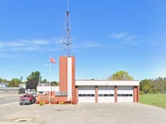
In 1970, a new Brighton Fire Hall was built at the corner and is still active as of this writing in 2026.
The east corner of Alice and Elizabeth was empty until 1969 when the Board of Education sold 0.55 acres of land at the south-west corner of the block to the Village of Brighton.
In 1970, a new Brighton Fire Hall was built at the corner and is still active as of this writing in 2026.
24 Elizabeth Street
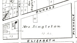
A school has been location at 24 Elizabeth Street since 1913. The Belden County Atlas map of 1878 shows that this 10-acre block was still owned by Mrs. Singleton, which in this case refers to Leonora Emily Singleton (1822-1909), the youngest child of John Singleton and Margaret Canniff. Leonora Singleton remained single and participated intensely in the real estate projects of her family, often exchanging properties with her mother and siblings.
The land transactions are very confusing in this period. However, it is clear that Margaret Singleton sold “the south part of the west half” of lot 35 to her daughter, Leonora, in 1861. Margaret had acquired large parts of lot 35 a few years before when another of her children, Abraham C. Singleton, took on the land from the others in the family but was not able to discharge several mortgages. Withing a few years, his mother had to come in to bail him out. The mortgages ended up with the Trust and Loan Company and, in 1861, Margaret Singleton bought the west half of Lot 35 from Trust and Loan. Very quickly, Margaret passed some of that land to her youngest daughter, Leonora.
Leonora Singleton held this land until 1905 when she sold it to Henry Meade, the son of Dr. Henry Meade. The younger Henry Meade was trying to manage his father’s extensive real estate portfolio, along with his mother, but by the 19-teens, Henry was living in Toronto. In 1925, he would die in the Homewood Sanitorium in Guelph. So, in 1913, he was moving property along and one example was the block bounded by Elizabeth, Alice, Dundas and Pinnacle Streets.
Some of this land had been sold to William Coyle in the 1870s so he could set up his blacksmith shop on the south side of Dundas Street, east of Alice Street, near what is labelled as Lot 19 on the map. This worked well for Mr. Coyle because his family home was just across Alice Street in what is now the parking lot for the library and municipal office.
Leonora Singleton held this land until 1905 when she sold it to Henry Meade, the son of Dr. Henry Meade. The younger Henry Meade was trying to manage his father’s extensive real estate portfolio, along with his mother, but by the 19-teens, Henry was living in Toronto. In 1925, he would die in the Homewood Sanitorium in Guelph. So, in 1913, he was moving property along and one example was the block bounded by Elizabeth, Alice, Dundas and Pinnacle Streets.
Some of this land had been sold to William Coyle in the 1870s so he could set up his blacksmith shop on the south side of Dundas Street, east of Alice Street, near what is labelled as Lot 19 on the map. This worked well for Mr. Coyle because his family home was just across Alice Street in what is now the parking lot for the library and municipal office.
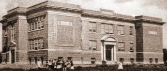
However, the bulk of the block was still unused in 1913 when Henry Meade sold 12 acres of land, excluding the Coyle piece, to the Board of Education.
Sam Nesbitt provided a donation of $10,000, Henry Meade sold the land for $2,500 and the school was built on the north side of Elizabeth Street, more-or-less in the middle between Alice and Pinnacle. The school opened in 1915.
Sam Nesbitt provided a donation of $10,000, Henry Meade sold the land for $2,500 and the school was built on the north side of Elizabeth Street, more-or-less in the middle between Alice and Pinnacle. The school opened in 1915.
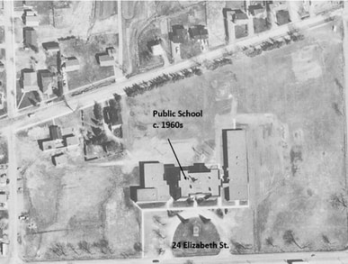
The next big move was to build a new and modern high school, so the older kids moved out if the school at 24 Elizabeth Street in 1955, to take up residence on Dundas Street a bit east of Pinnacle Street, now called Terry Fox Drive.
The public school continued on Elizabeth Street, adding extensions to the building so that, in the 1960s aerial photo at left, it has a much larger footprint.
Also notice that this was before the Municipal Office and Library at Alice Street and the Brighton Fire Hall at the corner of Alice and Elizabeth Streets.
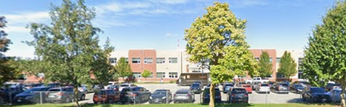
More recently, in 2012, the old school was completely removed after a new school had been built beside it.
The public school continued on Elizabeth Street, adding extensions to the building so that, in the 1960s aerial photo at left, it has a much larger footprint.
Also notice that this was before the Municipal Office and Library at Alice Street and the Brighton Fire Hall at the corner of Alice and Elizabeth Streets.
More recently, in 2012, the old school was completely removed after a new school had been built beside it.
64 Elizabeth Street
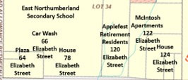
East of the new school, we cross Pinnacle Street, now called Terry Fox Drive, and move into a mixed commercial and residential area along the north side of Elizabeth Street. The map at right shows the next several address to deal with in this area.
The property to the east of Pinnacle Street is in Lot 34, Concession A, and this is another area that was not sub-divided until after the 1866 Brighton Plan and the 1878 Belden County Atlas. Snips from both of these demonstrated that in 1866, this area was owned by W. C. Proctor and in 1878 by I.O. Procter. In those days, there was some farming being done in this space between Elizabeth and Dundas Street, but mostly based on leases from the Proctor family. There was a lot of speculation over many decades as these lands outside of town became more in demand for the purposes of town people as opposed to farmers. For a long time, there was little change.
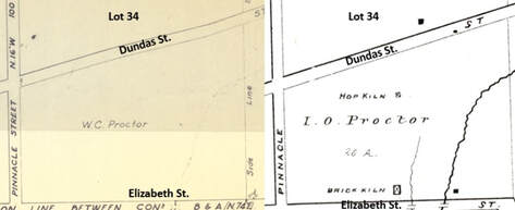
The Patent from the Crown for all 200 acres of lot 34 was granted to Kings College in 1828, meaning it was a government reserve designed to provide funds for education in the future. Lot 34 sat unused for a long time, until 1853, when the estate of Isaac C. Proctor passed it to his two sons, William Chamberlain Proctor (1832-1913) and Isaac Oscar Proctor (1836-1916). William was to get the west quarter pf lot 34 and Oscar the east half of the west half. Both of these men remained single and were very active in business and real estate, along with their brother, John Edward Proctor (1824-1911) who outdid them all. The land records are packed with these names.
In this case, we see that these two brothers, William and Oscar, did not get along with each other, at least in the real estate word. A transaction in 1875 shows that William sold the south half of lot 34 to Oscar. Interestingly, there are no other transactions in the records for lot 34 until 1901 when we see a series of items through 1905 where the Grantor is “High Court of Justice”. In all these transactions, William Proctor is the Plaintiff and Oscar is the Defendant. Oscar appears to have won every time.
The first meaningful transaction in the records is in 1913 when Isaac O. Proctor sold the entire 200 acres of Lot 34 to Samuel Tackaberry. Samuel Harrison Tackaberry (1865-1941) was born in Watertown, New York, a son of Nathaniel Tackaberry and Eliza J. Van Wicklin. Samuel’s father appears to have died not long after he was born and his mother brought the family to Brighton Township where others of her family lived. They were here for the 1871 Census, shown living north-west of Brighton.
In this case, we see that these two brothers, William and Oscar, did not get along with each other, at least in the real estate word. A transaction in 1875 shows that William sold the south half of lot 34 to Oscar. Interestingly, there are no other transactions in the records for lot 34 until 1901 when we see a series of items through 1905 where the Grantor is “High Court of Justice”. In all these transactions, William Proctor is the Plaintiff and Oscar is the Defendant. Oscar appears to have won every time.
The first meaningful transaction in the records is in 1913 when Isaac O. Proctor sold the entire 200 acres of Lot 34 to Samuel Tackaberry. Samuel Harrison Tackaberry (1865-1941) was born in Watertown, New York, a son of Nathaniel Tackaberry and Eliza J. Van Wicklin. Samuel’s father appears to have died not long after he was born and his mother brought the family to Brighton Township where others of her family lived. They were here for the 1871 Census, shown living north-west of Brighton.
Samuel Tackaberry married Sophia Ann Macklam in 1890 and worked in Brighton as a harness maker. His wife died in 1899 and he married his second wife, Maude Mullett, in 1901. There would be four children that lived past infancy. In 1891, Samuel had gained an interest in a house at 148 Main Street, towards the west end of town. However, by 1913, he was farming and decided to go into the job full-scale by buying his own farm land. The 200 acres of lot 34 would do just fine.
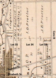
At right is a snip of the Belden County Atlas Map for 1878 showing the length of lot 34 from Elizabeth Street all the way north to White’s Road. We tend to concentrate on the part of lot 34 between Dundas and Elizabeth Streets, but it was much more than that. There was extensive farm land to the north of town in all three of lots 33, 34 and 35.
At right is a snip of the Belden County Atlas Map for 1878 showing the length of lot 34 from Elizabeth Street all the way north to White’s Road. We tend to concentrate on the part of lot 34 between Dundas and Elizabeth Streets, but it was much more than that. There was extensive farm land to the north of town in all three of lots 33, 34 and 35.
Over time, the town moved east and the Tackaberry land was sold off one small village lot at a time. Bigger spaces were sold for the new high school in 1954, the agricultural office, and Applefest Lodge. Selling small bits of land on the far south-west corner would be welcome in 1947, but it was small in comparison with their overall holdings.
Harrison Tackaberry (1903-1974), a son of Samuel, sold the small property at the corner of Elizabeth and Pinnacle Streets to William Conn. William Henry Conn (1893-1965) was born in Nova Scotia and lived for a time in Essex County, Ontario. He has no family connection in this area, so is not included in TreesByDan.com. However, he and his wife moved to Brighton in the early 1940s where he brought his financial resources into play by buying and selling businesses and investing in real estate. Here was a case where he purchased a very strategic corner lot on the main highway with the idea of building a service station for all those cars on the road. There had been small garages at this same location since 1936, operating for short periods by Herb Sweetman, Ivan Loveless, Alfred Brown and Sam Swain.
After acquiring the land, William Conn quickly had a modern service station built here, one that would have gas pumps near the road and service bays for maintenance and repair. By 1949, he had the station operating and sold it to Joseph McAnally, a fellow from Toronto who was engaged in the gas station business in other places in town. They called it the Mid Way Service Station.
Harrison Tackaberry (1903-1974), a son of Samuel, sold the small property at the corner of Elizabeth and Pinnacle Streets to William Conn. William Henry Conn (1893-1965) was born in Nova Scotia and lived for a time in Essex County, Ontario. He has no family connection in this area, so is not included in TreesByDan.com. However, he and his wife moved to Brighton in the early 1940s where he brought his financial resources into play by buying and selling businesses and investing in real estate. Here was a case where he purchased a very strategic corner lot on the main highway with the idea of building a service station for all those cars on the road. There had been small garages at this same location since 1936, operating for short periods by Herb Sweetman, Ivan Loveless, Alfred Brown and Sam Swain.
After acquiring the land, William Conn quickly had a modern service station built here, one that would have gas pumps near the road and service bays for maintenance and repair. By 1949, he had the station operating and sold it to Joseph McAnally, a fellow from Toronto who was engaged in the gas station business in other places in town. They called it the Mid Way Service Station.
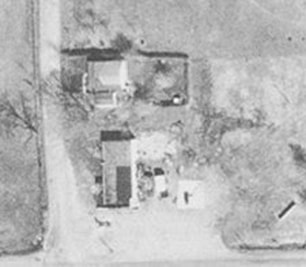
Sadly, in February of 1950, the service station was destroyed by fire and Joseph McAnally sold it a few months later to Ivan O. Whalen, another fellow involved with gas stations in town. Whalen rebuilt the service station and swung an agreement with the British American Oil Company for product and support. Then in 1951, he sold the place to George and Hilda Rowan. Mr. Conn had built a modern house immediately east of the service station where the owner could live, so George and Hilda made it their home. George made another agreement with the British American Oil Company, but his health failed. Hilda bought the home from Mr. Conn and had to sell the whole property in 1953 to Leonard Sheldrick. There were a few operators in the next couple of years, none lasting very long. It gets very confused.
What was much more clear was the fact that the gas station at the corner would have one monstrous new neighbour. In 1945, Harrison Tackaberry sold a large section of lot 34 north of highway 2 and south of Dundas Street to the school board and the new high school was built. Now the service station had the school parking lot to the north and the running track to the east. And lots of kids to cope with.
By 1965, it was a Sunoco station and there was a re-opening of the fully renovated facility. In 1977 there was another bad fire but the station was rebuilt. To meet demand, there was more support for food sales. Then, in 1989, redevelopment was the order of the day. The service station was demolished and a commercial plaza built to support several tenants. Today, we have the laundromat at the east end, the Subway, with a convenience store and pizza place. Many of the teenagers at the high school see this plaza as a necessary part of their school day.
By 1965, it was a Sunoco station and there was a re-opening of the fully renovated facility. In 1977 there was another bad fire but the station was rebuilt. To meet demand, there was more support for food sales. Then, in 1989, redevelopment was the order of the day. The service station was demolished and a commercial plaza built to support several tenants. Today, we have the laundromat at the east end, the Subway, with a convenience store and pizza place. Many of the teenagers at the high school see this plaza as a necessary part of their school day.
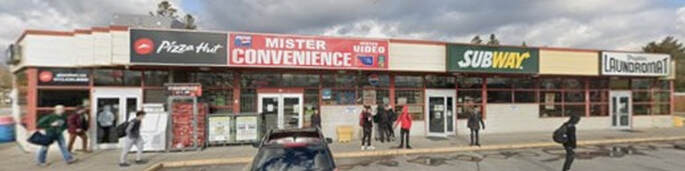
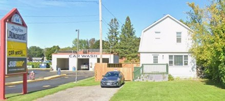
There has been a car wash facility at the far east end of the plaza since 1991. The house that William Conn built with the new service station in 1945 is 74 Elizabeth Street. Service Station owners lived there for some time, although Paul Kusmitch is shown living at 64 Elizabeth in the 1968 Canada Voters Lists. After the plaza was built, it became a private residence.
120 Elizabeth Street
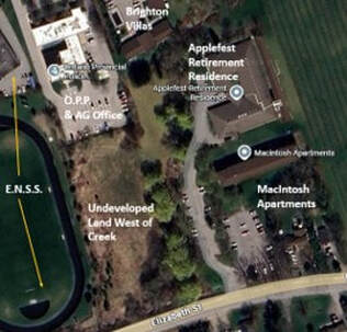
The next property to the east is 120 Elizabeth Street which is the Applefest Retirement Residence. The E.N.S.S. track takes up some distance of Elizabeth Street and then there is an undeveloped area west of the creek. The next driveway is shared by Applefest and the McIntosh Apartments. We can gain further orientation by seeing that the O.P.P. and Agricultural offices are immediately north of the undeveloped area and Brighton Villas are immediately north of Applefest. Also note that there are two house lots on Elizabeth Street at the far east side of the area, immediately south of the McIntosh Apartments
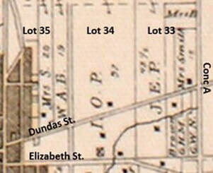
Another important fact to mention here is that the far eastern border of this area is also the easter border of lot 34. The 1878 map shows the creek running from the south to the east sided of lot 34 and the border between lot 34 and 33 is where the highway starts to bend to the south to avoid the ridge.
The land records for the area where #120 and #122 are located are the same as properties immediately to the west up to and including 1913 when Isaac O. Proctor sold all 200 acres of lot 34 to Samuel Tackaberry. Samuel Harrison Tackaberry (1865-1941) died Jul 4 1941 in Brighton. There are no transactions in the land records to reflect the inheritance of the land from Samuel to his children.
The land records for the area where #120 and #122 are located are the same as properties immediately to the west up to and including 1913 when Isaac O. Proctor sold all 200 acres of lot 34 to Samuel Tackaberry. Samuel Harrison Tackaberry (1865-1941) died Jul 4 1941 in Brighton. There are no transactions in the land records to reflect the inheritance of the land from Samuel to his children.
Then, in 1954, Harrison M. Tackaberry sold part of the family land holdings to Willard V. Tackaberry. Harrison Mullett Tackaberry (1903-1974) was a son of Samuel Tackaberry and Maude Mullett. He remained unmarried and continued farming. Willard Vanwicklin Tackaberry (1906-2000) was a son of Samuel Tackaberry & Maude Mullett and he married Muriel Mildred Young in 1933. They had one son, Harry. So, Harrison and Willard were brothers.
The next important transaction was in 1954 when Harrison Tackaberry granted the bulk of the remaining Tackaberry land holdings to his brother Willard. The next transaction of note was in 1976 when Plan 38R-1030 was registered, indicating the separation of 1 acre of land. Then, in 1978, Willard Tackaberry sold the land from Plan 38R-1030 to his wife Muriel.
The next year, two new plans defined as series of small plots on the land north of Elizabeth Street up to the eastern border of lot 34. In effect, the transaction listed a series of small lots combined to make up the land that would be used for Applefest Retirement Residence, which would be 120 Elizabeth Street. It also made the same kind of list of small lots that would make up the McIntosh Apartments which would be 122 Elizabeth Street.
Several complex transactions follow which deal with Robert A. McEwan Ltd. who was the contractor for this project. In 1985, there are several transactions where the Grantor is Robert A. McEwan Ltd. and the Grantee is Applefest Lodge Limited Partnership. By 1989, transactions evolved into using numbered companies.
The next important transaction was in 1954 when Harrison Tackaberry granted the bulk of the remaining Tackaberry land holdings to his brother Willard. The next transaction of note was in 1976 when Plan 38R-1030 was registered, indicating the separation of 1 acre of land. Then, in 1978, Willard Tackaberry sold the land from Plan 38R-1030 to his wife Muriel.
The next year, two new plans defined as series of small plots on the land north of Elizabeth Street up to the eastern border of lot 34. In effect, the transaction listed a series of small lots combined to make up the land that would be used for Applefest Retirement Residence, which would be 120 Elizabeth Street. It also made the same kind of list of small lots that would make up the McIntosh Apartments which would be 122 Elizabeth Street.
Several complex transactions follow which deal with Robert A. McEwan Ltd. who was the contractor for this project. In 1985, there are several transactions where the Grantor is Robert A. McEwan Ltd. and the Grantee is Applefest Lodge Limited Partnership. By 1989, transactions evolved into using numbered companies.
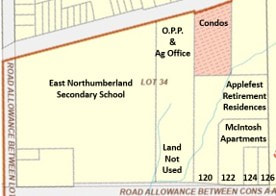
In modern terms, the OnLand.ca map shows that there is one long lot from Highway 2 to Dundas Street containing undeveloped land to the south and the O.P.P. property to the north. The next lot is for Applefest, which formas an “L” shape north of the apartments. The next lot is for the McIntosh Apartments, leaving two house lots along No. 2 on the far south-east corner of the old lot 34. These are #124 and #126 Elizabeth Street, properties that had been established with houses as far back as 1948.
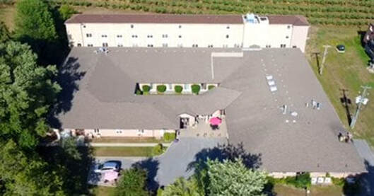
Here is an aerial view of the Applefest Retirement Residence taken from their web site. The front door is at the middle of the picture which faces toward the east. The original structure is one storey but the newer residence building along the east side has three levels.
124 Elizabeth Street
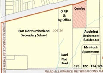
Before we venture out of lot 34, there are two more properties to deal with. These are #124 and #126, small residential lots on Elizabeth Street. These will take us up to the eastern border of lot 34.
The land records for 124 Elizabeth Street are the same as the properties to the west up to and including 1913 when Samuel Tackaberry acquired all 200 acres of lot 34 from Isaac O. Proctor. The next transaction related to #124 is in 1948 when brothers Harrison and Willard Tackaberry, along with their sister, Gladys West, sold part of lot 34 to Kenneth and Marjorie Gotsell.
The land records for 124 Elizabeth Street are the same as the properties to the west up to and including 1913 when Samuel Tackaberry acquired all 200 acres of lot 34 from Isaac O. Proctor. The next transaction related to #124 is in 1948 when brothers Harrison and Willard Tackaberry, along with their sister, Gladys West, sold part of lot 34 to Kenneth and Marjorie Gotsell.
Marjorie Jean Sharpe (1915-2005) was born near Hilton, a daughter of Charles Sharpe and Florence Hawley. In 1934, she married Kenneth William Gotsell (1912-1987) who was born in Norfolk, England, a son of John Henry Gotsel and Beatrice Beard. Kenneth appears to have come to Canada by himself in 1930, at the age of 19. He worked on a farm in Murray Township but later became a bricklayer and then a contractor. Kenneth and Marjorie had no children, stayed in Brighton and are buried in Mount Hope Cemetery.
Since Kenneth Gotsell was a contractor, he may have built a house on the lot. Two years later, in 1950, he sold the property to Lillian Marjorie Avery, wife of Charles Avery of Peterborough. They were there until 1962 when they sold to James and Elizabeth Trumbley.
Since Kenneth Gotsell was a contractor, he may have built a house on the lot. Two years later, in 1950, he sold the property to Lillian Marjorie Avery, wife of Charles Avery of Peterborough. They were there until 1962 when they sold to James and Elizabeth Trumbley.
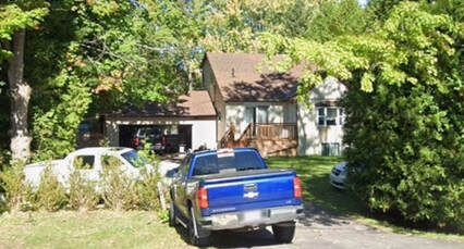
James Ernest Trumbley was born in Cookstown, Ontario, a son of John Aylmer Trumbley and Alice Turner. He married Elizabeth Joyce Macleod in 1956 and they had at least two children, Helen and Donald. Both James and Elizabeth Trumbley died in Trenton in 2003 and the property went to their son, Donald Eric Trumbley. He married Doreen Fay Boville and the records for the property at 124 Elizabeth Street show they were there at least to 2008.
126 Elizabeth Street
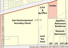
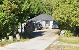
The property at 126 Elizabeth Street is a small lot fronting on Elizabeth Street, which is also No. 2 Highway. It is the easterly-most of two such lots, including 124 Elizabeth Street, just to the west. These are both relatively modern homes not far from the road but largely hidden by trees. You will almost miss the driveways if you are not watching closely. The OnLand.ca map shows these two small lots which are at the far south-east corner of the old lot 34. These properties represent the far south-eastern extent of lot 34.
The land records for 126 Elizabeth Street are the same as the properties to the west up to and including 1913 when Samuel Tackaberry acquired all 200 acres of lot 34 from Isaac O. Proctor. The next transaction related to 126 Elizabeth Street was in 1948 when brothers Harrison and Willard Tackaberry, along with their sister, Gladys West, sold part of lot 34 to Wilfred N. Ferguson and Helen I. Wood. This couple sold the property in 1952 to Victor H. & Gertrude Valleau who sold the next year to James H. Bradshaw. The next year, he transferred the property to himself and his wife, Violet. In the Canada Voters Lists for 1965, 1968 and 1973 this couple is shown to be living at 126 Elizabeth Street.
James Bradshaw died in 1974 and his estate, through Violet, sold to Wyman and Elizabeth Roberts. They owned the place until 1985 when they sold to John Lawrence and Marion Elizabeth Greveling. They sold in 1988 to Edward Paul and Anna Cayle D’eon and then sold in 1990 to James and Cathy Gibson. In 1994 they sold to Walter William and Rheta Joyce Askew. They sold in 2008 to Harold Raymond Gerow, a member of the family who operates Gerow Propane to the east of Brighton.
The property at #126 is the current extent of the work on Elizabeth Street.
The property at #126 is the current extent of the work on Elizabeth Street.